Volume 13 Issue 1 *Corresponding author adriene.duarte@yahoo.com.br Submitted 2 Feb 2025 Accepted 31 Mar 2025 Published 7 Apr 2025 Citation DUARTE, A. S.; SANTOS, C. J. B.; LOPES, R. S.. Tracks of the past: a cartographic journey through the tram lines of Rio de Janeiro in 1910. Coleção Estudos Cariocas, v. 13, n. 1, 2025.
DOI: 10.71256/19847203.13.1.131.2025 The article was originally submitted in PORTUGUESE. Translations into other languages were reviewed and validated by the authors and the editorial team. Nevertheless, for the most accurate representation of the subject matter, readers are encouraged to consult the article in its original language.


| Tracks of the past: a cartographic journey through the tram lines of Rio de Janeiro in 1910 Trilhos do passado: uma jornada cartográfica pelas linhas de bonde do Rio de Janeiro em 1910 Rieles del pasado: un viaje cartográfico a través de las líneas de tranvía de Río de Janeiro en 1910 Adriene dos Santos Duarte¹*, Claudio João Barreto dos Santos²
and Renato da Silva Lopes³ 1Escola Nacional de Ciências Estatísticas - ENCE/IBGE, R. André Cavalcanti, 106 - Centro, Rio de Janeiro - RJ, 20231-050, ORCID 0000-0001-9695-579X, adriene.duarte@yahoo.com.br 2Universidade do Estado do Rio de Janeiro, Rua São Francisco Xavier, 524, Maracanã, Rio de Janeiro – RJ – CEP: 20550-900, ORCID 0000-0001-8966-3342, cljclj6@gmail.com 3Fundação Oswaldo Cruz - Fiocruz, Av. Brasil, 4036 - Manguinhos, Rio de Janeiro - RJ, 21040-361, ORCID 0009-0008-4665-9309 , renato.engcarto@gmail.com
AbstractThe article contributes to urban history by applying historical cartography and Geographic Information Systems (GIS) to reconstruct the itineraries of trams in Rio de Janeiro during the 20th century, especially during the transition from animal traction to electric power. Using GIS tools, historical maps were georeferenced and vectorized, allowing for the precise reconstruction of the routes. The results reveal transformations in urban mobility and the influence of technological innovations on transportation. The research values historical heritage and enhances historical cartography methodologies, expanding their use in urban studies, memory preservation, and the analysis of transportation evolution. Keywords: Historical Cartography, Trams, Urban Mobility ResumoO artigo contribui para a história urbana ao aplicar cartografia histórica e Sistemas de Informação Geográfica (SIG) na reconstrução dos itinerários dos bondes do Rio de Janeiro no século XX, especialmente durante a transição da tração animal para a elétrica. Utilizando ferramentas GIS, mapas históricos foram georreferenciados e vetorizados, permitindo a reconstrução precisa dos trajetos. Os resultados revelam transformações na mobilidade urbana e a influência das inovações tecnológicas no transporte. A pesquisa valoriza o patrimônio histórico e aprimora metodologias de cartografia histórica, ampliando seu uso em estudos urbanos, preservação da memória e análise da evolução dos transportes. Palavras-chave: Cartografia Histórica, Bondes, Mobilidade Urbana ResumenEl artículo contribuye a la historia urbana al aplicar la cartografía histórica y los Sistemas de Información Geográfica (SIG) para reconstruir los itinerarios de los tranvías en Río de Janeiro en el siglo XX, especialmente durante la transición de la tracción animal a la eléctrica. Utilizando herramientas SIG, se georeferenciaron y vectorizaron mapas históricos, lo que permitió reconstruir con precisión las rutas. Los resultados revelan transformaciones en la movilidad urbana y la influencia de las innovaciones tecnológicas en el transporte. La investigación valora el patrimonio histórico y mejora las metodologías de la cartografía histórica, ampliando su uso en estudios urbanos, conservación de la memoria y análisis de la evolución del transporte. Palabras clave: Cartografía histórica, Tranvías, Movilidad urbana |
Introduction
The relationship between map production and the trajectory of humanity is vast and multifaceted. In the field of urban history, this connection becomes even more evident, especially when integrating historical cartography with new technologies. Advances in computational tools have played a fundamental role in creating innovative methodologies for analyzing and recovering information found in historical cartographic documents, such as maps and plans. Modern tools like GIS allow the overlaying of historical and contemporary maps, facilitating the analysis of urban and territorial evolution. These technological resources enable a deeper understanding of spatial changes, permitting the study of the evolution of cities and the societies that develop within them.
For Menezes,
Historical maps are excellent temporal archives, acting as era-specific records for a given geographic space. They provide the basis for correctly positioning space in time, thereby enabling the recovery of period-specific information and establishing the characterization of evolutionary studies on trends of land occupation and landscape use in general (Menezes et al., 2005).
Historical maps, as highlighted by Menezes (et al., 2005), act as temporal records that enable the recovery of period-specific information and the analysis of their evolution. However, their relevance extends beyond mere documentation. Beyond archiving spatial transformations, maps play an active role in organizing territory and constructing geographic knowledge. Thus, historical cartography not only identifies evolutionary trends in landscapes but also consolidates itself as an essential tool for interpreting and reconstructing pivotal periods of urban history.
Therefore, historical maps are interconnected with both the past and the present, documenting the territorial dynamics of their time while providing insights for planning and managing geographic space today. They are windows to the past, allowing not only the observation of spatial transformations but also an understanding of the social, economic, and political dynamics that shaped these changes.
From Fernandes’ perspective,
The multiple applications of Historical Cartography, brought into the present and even predictive studies projecting into the future, offer a glimpse of the breadth of work that can be developed. On the other hand, rescuing past information through maps creates the satisfaction of time travel, transporting researchers to the moment they seek to answer questions formulated in the present (Fernandes et al., 2021, p. 87).
The relationship between past and present, emphasized by Fernandes (et al., 2021), finds a practical application in the vast historical-cartographic collection of Rio de Janeiro. Maps, plans, and ancient documents not only recorded the city’s transformations over the centuries but also enabled researchers to reflect on the spatial dynamics of the time, aiding in the interpretation of territories and the formulation of new perspectives on urban development. Thus, historical cartography is not limited to memory retrieval but asserts itself as an essential instrument for understanding the city’s trajectory and informing reflections on its urban configuration. As Campos (2016) points out, historical maps are not neutral portraits of space but expressions of interests and disputes that shaped Rio’s urbanization.
This relationship between cartography and urbanization is clearly reflected in urban mobility, one of the primary vectors of spatial transformation over time. In the case of Rio de Janeiro, historical maps recorded not only the city’s territorial configuration but also changes in transportation infrastructure that influenced its expansion. Trams, for example, were pivotal in this process, established as structuring agents of the urban fabric since the 19th century and directly impacting spatial organization and the city’s dynamics.
In this context, historical cartography plays an essential role in supervising the Tram routes of Rio de Janeiro during this transition. Analyzing old maps allows us to understand the evolution of trajectories, identify changes in route layouts, and interpret the socioeconomic influences that shaped the city’s transportation configuration. Using georeferencing and vectorization techniques, this study seeks to recover and spatially represent the trajectories of tram lines in 1910, providing a detailed view of mobility dynamics at the time and their relationship with Rio’s urban growth.
Given this, the main objective of this article is to reconstruct the tram routes of Rio de Janeiro in the early 20th century, emphasizing the transformations during the transition from animal to electric traction. The methodology involves the use of Geographic Information Systems (GIS) to analyze and georeference historical maps, enabling the overlay of spatial information from different periods. This approach allows for a precise spatial reconstruction of urban infrastructures and their evolution over time. By retracing these routes, the study aims not only to provide a detailed view of urban mobility at the time but also to contribute to preserving urban memory and understanding the transformations that shaped the city’s territorial and social development (Carvalho, 2014).
Brief Contextualization
During the colonial period, transportation methods were quite rudimentary. Sedan chairs, small litters, and hammocks were used for short distances, while boats and horseback riding were common for longer journeys. With the arrival of the Portuguese court in 1808, the city grew rapidly, increasing the demand for a more efficient public transportation system.
In 1817, the first stagecoaches emerged, followed by gondolas in 1838, buses in 1842, and tílburis (light carriages) in 1846, all powered by animal traction. The introduction of trams in 1868 marked a major advancement. Initially pulled by donkeys and horses, trams facilitated urban expansion and connected different areas of the city. As highlighted by Weid,
Existing transports were pulled by horses or donkeys. These included tílburis or calèches — vehicles for individuals or small groups — carts for cargo, and stagecoaches, buses, and gondolas, which were the collective transport options available. Stagecoaches were large carriages pulled by four horses. They were used for longer trips and had limited passenger capacity. "They carried barefoot passengers without collars... and transported bundles of clothes, small cargo, and trays of sweets, vegetables, and fruits sold by street vendors" (Weid, 1994, p. 5).
As one of the city’s first public transportation infrastructures, trams were pivotal in structuring urban space and driving the capital’s economic growth. However, their operation faced significant challenges, such as low speed, limited capacity, and reliance on animal power, which became increasingly incompatible with a city undergoing rapid modernization and population growth.
They quickly became an essential part of the city’s transportation infrastructure. Yet, with population growth and the need for a more efficient system, the electrification of tram lines became a priority to align with the urban and economic development of the Brazilian capital:
Most human activities involve moving from one place to another. Thus, concerns about mobility — distance, routes, time, and safety — are inherent to humanity’s development process. When it comes to urban mobility, these concerns have accompanied the evolution and trends of urbanization throughout history (Lopes et al., 2021, pp. 22–23).
From the second half of the 19th century, trams began transitioning to steam and later electric power:
In Brazil, iron-rail trams with animal traction were the first collective transport services. Operated in Rio de Janeiro by the “Companhia de Carris de Ferro da Cidade à Boa Vista na Tijuca” — one of the companies granted concession through an Imperial Decree in 1856 — the inaugural journey took place in January 1859, with Emperor Pedro II in attendance. There were only two vehicles. The first route ran from Ouvidor Street in the city center to Largo do Machado in Catete. The cars were closed and could carry up to thirty passengers (...). After three years of animal traction, these were replaced by small steam locomotives (...) (Lopes et al., 2021, p. 32).
By the end of the century, tram electrification marked a crucial moment in the city’s public transportation history. However, this transition was not abrupt but the result of a gradual process involving multiple companies, concessions, and urban infrastructure transformations. Starting in 1890, company concessions included clauses mandating line electrification, as noted by Weid:
By the late 19th century, new energy sources emerged with the discovery of electricity, and experiments with new systems began. When tram company concessions were renewed in 1890, one clause inserted into nearly all contracts was the requirement to electrify lines (Weid, 1994, p. 18).
The introduction of electricity opened new prospects for trams, promoting greater operational efficiency, cost reduction, and increased passenger capacity. More than an innovation, electrification was part of a broader context of profound urban transformation driven by ideals of modernity and progress. This advancement not only upgraded the transportation system but also altered the urban landscape and spatial organization, redefining central and peripheral areas of Rio de Janeiro.
Starting in 1892, experiments with electric trams accelerated the transition. The Companhia Ferro Carril do Jardim Botânico was among the first to adopt electrification in 1896, followed by the Companhia Ferro Carril Carioca, which modernized operations to meet growing public transportation demand. Infrastructure such as the Riachuelo Street thermoelectric power plant was critical to enabling this modernization, ensuring the energy supply needed for the new transport model’s expansion.
In subsequent years, companies like the Estrada de Ferro da Tijuca extended the electric network to peripheral areas, influencing new dynamics of urban occupation (Weid, 1994). Tram electrification not only improved urban mobility but also contributed to real estate valorization and neighborhood expansion, consolidating new centralities and urbanization patterns.
The early 20th century was marked by the Reforma Passos (1902–1906), inspired by Paris’s Haussmann model, which promoted profound urban reconfiguration in Rio de Janeiro. This modernization-focused reform included the elimination of tenements, street widening, and the implementation of new road infrastructure. Tram electrification accompanied this process, cementing itself as a key element in transforming mobility and redefining urban flows. The inauguration of Central Avenue and the construction of Beira-Mar Avenue in 1904 exemplify how trams and modernization progressed hand in hand. Beyond facilitating transport, electric trams contributed to creating a more sophisticated and cosmopolitan urban image, aligned with European references of urban development.
From 1907 onward, with the entry of the Canadian company Rio de Janeiro Tramway, Light & Power Co. Ltda., a process of unifying and expanding electric tram networks began. This reorganization integrated old concessions and definitively replaced animal traction, establishing electric trams as the structural axis of Rio’s urban mobility. Additionally, this shift introduced a new transportation management model based on corporate efficiency and market expansion principles, aligning Rio de Janeiro with standardized urban services administered by foreign companies. This context reflects not only technological advancement but also the complex interplay between public authority and private capital in modernizing urban infrastructure. From Weid’s perspective:
Company mergers were also typical in the expansion of tram lines in the capital. Except for the Companhia do Jardim Botânico, all others grew by absorbing smaller firms operating in adjacent areas. This strategy reveals a trend toward monopolization. By the late 19th century, the city was divided among four or five major companies (Weid, 1994, p. 29).
Examining tram routes over time reveals that their trajectories were not merely responses to spontaneous public demand but also the result of political and economic strategies aimed at directing the city’s growth. The implementation of tram lines directly impacted urban spatial structuring, encouraging occupation of specific areas, fueling real estate speculation, and redefining territorial hierarchies. Thus, studying tram history is also studying the history of Rio de Janeiro’s organization and the interests that shaped its urban transformations.
Today, trams are largely remembered as nostalgic symbols of a bygone era, with some tourist lines still operating, such as the famous Santa Teresa trams. They have left a significant cultural legacy, often depicted in films, music, and literature, evoking a sense of romance and nostalgia. The popularity of trams in Rio de Janeiro aligned with a global trend, as many cities worldwide adopted tram systems in the late 19th and early 20th centuries.
Methodology
For this study, conducting a meticulous search for maps and plans documenting tram routes in Rio de Janeiro during the transition from animal to electric traction was essential. The difficulty in finding suitable maps highlights the challenges researchers face when working with historical documents. Historical maps were sourced from the Biblioteca Nacional Digital (BN Digital). However, the number of maps representing tram lines from this period was limited. Among the available documents, only one met the research criteria, considering factors such as preservation, scale, and legend (Figure 1).
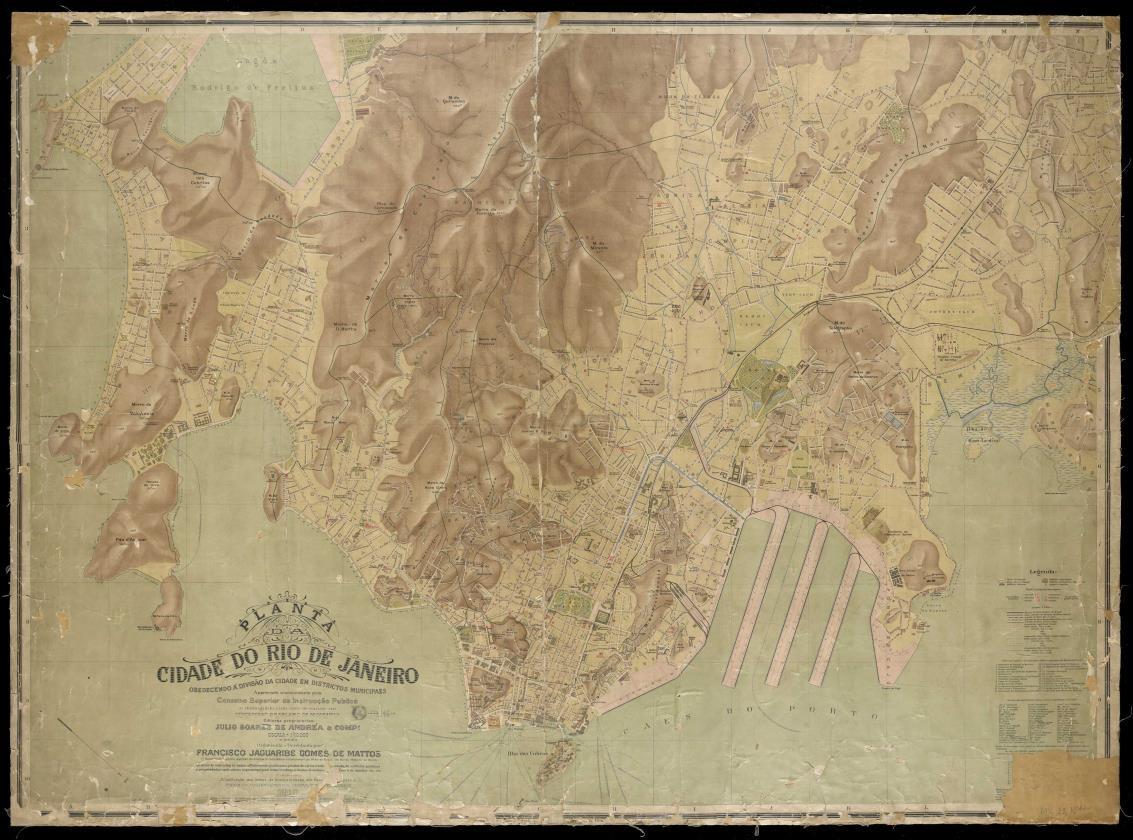
Figure 1: Map of the city of Rio de Janeiro (1910)
Source: BN Digital – National Library
The study focused on the transition period from animal to electric traction, spanning the late 19th and early 20th centuries—a time of significant impact on the city’s spatial organization. To reinforce the identification of active companies during this era, an enlarged legend from Francisco Jaguaribe Gomes de Matos’ Planta da Cidade do Rio de Janeiro (1910) was included, which references transportation companies (Figure 2).
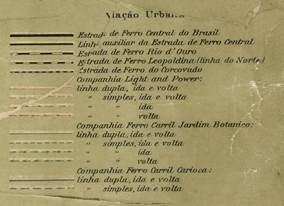
Figure 2: Enlarged legend of the Map of the City of Rio de Janeiro (1910)
Source: BN Digital – National Library
As a contemporary reference base, the Logradouros (Streets) and Limites de Bairros (Neighborhood Boundaries) layers provided by DATA.RIO were used, in shapefile (.shp) format, referenced to SIRGAS2000 and projected in the UTM Zone 23S system. These datasets were chosen for their compatibility with urban analyses and spatial accuracy, suitable for overlaying with historical maps.
To ensure proper integration of these datasets with historical maps, all features must be georeferenced. In this context, Teixeira and Christofoletti (1997) define georeferencing as the process of associating a feature with its real-world position through a known coordinate system, enabling precise identification of a point on the Earth’s surface. This procedure ensures spatial coherence and enables accurate analyses in reconstructing historical routes.
Thus, the georeferencing process in this study was performed relatively using the “Georeferencing” tool in ArcGIS 10.3. Control points were selected at overlapping features between historical maps and contemporary cartography, such as road intersections (Figure 3), ensuring adequate spatial correspondence.
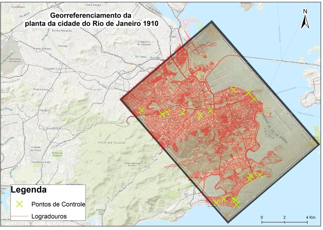 Figure 3: Georeferencing of the 1910 map
Source: Own elaboration, 2019.
After georeferencing, the operational tram routes from 1910 were vectorized and organized into shapefiles. According to Manenti et al. (2019):
On-screen vectorization is a manual method that involves drawing vectors over the map image using a mouse. It is performed in specialized drawing software, resulting in a vector map with separated features (p. 89).
Each dataset was structured to individually represent the companies operating during the period, enabling detailed analysis of their networks. These vector data were essential for creating thematic maps depicting the era’s transportation network. The maps were integrated with the Basemap (Topographic), allowing historical data to be overlaid and analyzed alongside contemporary spatial information. This integration facilitated the visualization of tram routes relative to the current urban configuration, enabling deeper, context-rich spatial analysis. This methodological approach aids in investigating, locating, and visualizing significant events within a specific time and space.
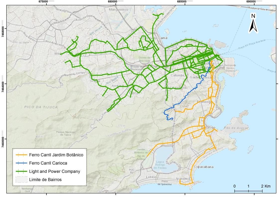
Figure 4: Vectorization of tram routes based on the 1910 map
Source: Own elaboration, 2019.
Results
The following maps illustrate the reconstruction of tram routes operational in Rio de Janeiro in 1910, based on georeferencing and manual vectorization of historical trajectories. Additionally, the lines were categorized according to the operating companies of the period, highlighting their spatial distribution. This process enables a clearer understanding of the tram system’s organization in the city and the urban dynamics associated with early 20th-century public transportation.
Among the companies active at the time, Ferro Carril Jardim Botânico played a central role in urban transport transformations, particularly during the transition from animal to electric traction between the late 19th and early 20th centuries. Its original route connected Praça XV de Novembro to Jardim Botânico, passing through strategic thoroughfares such as Primeiro de Março Street, Central Avenue (now Rio Branco Avenue), and Largo do Machado. This line was essential for urban expansion in the city’s southern zone, facilitating access to new neighborhoods and promoting the valorization of previously underdeveloped areas. Furthermore, it enhanced connectivity between the city center and key cultural and leisure spaces, such as the Jardim Botânico itself (Figure 5).
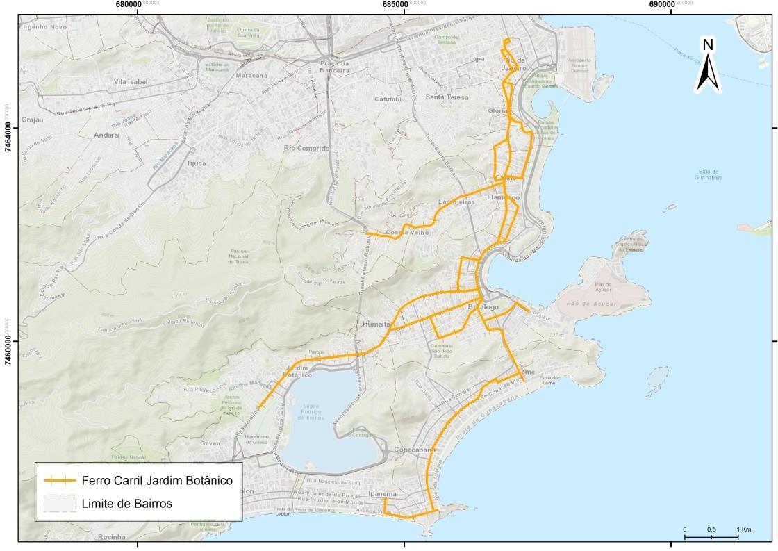
Figure 5: Itinerary of the Ferro Carril Jardim Botânico Company.
Source: Author’s elaboration. 2019.
In 1891, the Companhia Ferro Carril Carioca was inaugurated after acquiring the concession of the Plano Inclinado de Santa Teresa company, which had operated the line connecting Santa Teresa to the city center since 1885. The establishment of this new company marked a significant advancement in Rio de Janeiro’s urban mobility, solidifying Santa Teresa as one of the first neighborhoods with a regular rail-based public transport system. Additionally, the company obtained permission to expand its lines to Morro de Santo Antônio, enhancing connectivity between different city areas and improving population mobility.
The transition to a modernized system occurred in 1896, when Ferro Carril Carioca introduced electric traction to replace animal power. Electrification enabled a more efficient and agile service, increasing transport capacity and reducing travel times. Its upgraded lines connected strategic points such as Morro de Santa Teresa, Morro de Santo Antônio, and the Arcos da Lapa — one of central Rio’s key architectural landmarks (Figure 6).
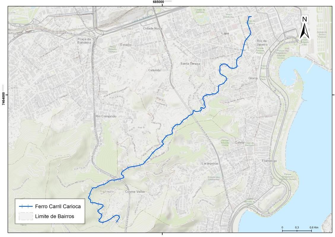
Figure 6: Itinerary of the Ferro Carril Carioca Company.
Source: Author’s elaboration. 2019.
Ferro Carril Carioca played a fundamental role in reconfiguring urban space, contributing to Santa Teresa’s residential expansion and its valorization as an attractive area for elites and the middle class. Over the decades, the tram system underwent numerous changes, including rail network reductions and line deactivations due to the rise of automobiles and buses in the 20th century. However, the company survived and continues to operate electric trams today, remaining the sole remnant of this historical period. The Santa Teresa tram is now one of Rio de Janeiro’s most iconic symbols, valued not only for its historical and cultural significance but also as a tourist attraction preserving 19th and early 20th-century public transport heritage.
The itinerary of the Tramway Light and Power Co. Ltda. covered extensive areas of Rio de Janeiro, connecting neighborhoods and key points critical to the era’s urban mobility. By 1910, Light’s tram network was fully electrified, marking a pivotal milestone in the city’s public transport evolution. This achievement represented not only modernization but also a leap in efficiency and capacity, allowing Light to dominate urban mobility infrastructure with a rapid and reliable tram system. During this period, the company functioned as a near-monopoly, consolidating its presence with an electric network that facilitated cariocas’ movement across diverse parts of the city (Figure 7).
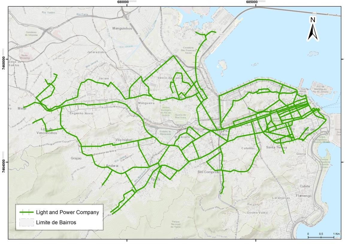
Figure 7: Itinerary of the Light and Power Company.
Source: Author’s elaboration. 2019.
Meanwhile, the Companhia Ferro Carril Jardim Botânico operated independently, competing directly with Light, particularly in the southern zone. This company connected high-profile neighborhoods such as Botafogo, Copacabana, Ipanema, and Leblon, offering transport alternatives to residents and a growing number of visitors. Concurrently, the Companhia Vila Isabel, under Light’s direction, expanded its lines to northern suburbs, reaching peripheral areas and extending electric transport to regions previously distant from urban centers.
Light’s strategy for expanding its electric transport system focused on modernizing older animal traction lines. The shift to electrification not only increased transport capacity but also enabled new routes that better integrated the city’s diverse areas. Electrification made the system more efficient, allowing greater speed, broader reach, and reduced operational costs. This modernization was vital for Rio de Janeiro during a period of accelerated urbanization and population growth in the early 20th century. The new electric tram network allowed the city to adapt to urban expansion, meeting rising demand for fast and accessible transportation.
Conclusion
The transition to electric traction in the early 20th century marked a significant milestone in Rio de Janeiro’s urban transformations, bringing substantial improvements to the transportation system. Electrification not only increased passenger capacity, service frequency, and efficiency but also enabled more effective integration of the city’s diverse regions. With electric trams, Rio de Janeiro underwent accelerated modernization, connecting the urban center to peripheral areas, facilitating expansion into new neighborhoods, and enabling the development of previously distant regions. The electric tram became a symbol of this transformation, reflecting both technological advancement and the profound social and cultural shifts that characterized the era of urban growth.
This transportation overhaul also solidified Rio de Janeiro as a model of a modern city, shaped by progress and the integration of urban and suburban areas. The tram routes, in particular, reveal mobility dynamics and urban planning intentions in a city striving for greater connectivity, reflecting the emergence of new standards of living and social organization. The digitization and vectorization of historical tram routes allowed for a more precise reconstruction of the 1910 lines, uncovering the territorial distribution of transportation infrastructure and its influence on urban configuration.
Analysis of the tram network from this period reveals a mobility model centered on Rio de Janeiro’s historic core, with lines radiating outward to expanding peripheral neighborhoods. This transportation pattern contributed to the formation of structural axes for urban growth, shaping territorial occupation patterns that persisted for decades and directly impacted the city’s development trajectory.
As Abreu (2005, p. 189-220) notes, historical cartography plays a fundamental role in understanding the evolution and structuring of space over time, enabling analysis of its configuration from origin to the present. With advances in geographic information systems and computational tools, it has become feasible to recover and process geographic data embedded in historical maps. Thus, current technology allows analog maps — valuable for their historical content — to be converted into digital environments, facilitating dynamic reconstruction and enabling observation of past spatial transformations through modern resources.
Reconstructing tram routes not only deepens our understanding of the city’s mobility evolution but also provides critical insights for analyzing challenges faced by contemporary public transportation. It allows comparisons between past issues and current solutions in infrastructure, mobility, and social integration. Ultimately, this historical analysis is an essential tool for comprehending urbanization processes and the ongoing transformations that continue to shape the city.
References
ABREU, Maurício A. Evolução Urbana do Rio de Janeiro. Rio de Janeiro: IPLANRIO, 1987.
ABREU, Maurício A. Reencontrando a antiga cidade de São Sebastião: mapas conjecturais do Rio de Janeiro do século xvi. Revista Cidades, Brasil, v. 2, n. 4, p. 189–220, 2021. DOI: 10.36661/2448-1092.2005v2n4.12599.
CARVALHO, Carlos Delgado de. História da Cidade do Rio de Janeiro. Rio de Janeiro: Biblioteca Carioca, 1990.
FERNANDES, Manoel do Couto; MENEZES, Paulo Márcio Leal de; CRUZ, Carla Bernadete Madureira. Cartografias do Ontem, Hoje e Amanhã. Curitiba: Appris, 2022.
LOPES, Dario Rais; MARTORELLI, Martha; VIEIRA, Aguiar Gonzaga. Mobilidade urbana: conceito e planejamento no ambiente brasileiro. Editora Appris, 2021.
MENEZES, P. M. L., LEPORE, V. M. G., FERREIRA, T. S. Cartografia Histórica como suporte para análise geográfica. IV Colóquio Brasileiro de Ciências Geodésicas, 2005.
SANTOS, M. M. D. OLIVEIRA, P. M. L. Georreferenciamento de mapas históricos. Geografias, v. 6, n. 2, p. 92-105, 2010. Available at: https://periodicos.ufmg.br/index.php/geografias/article/view/13268. Accessed: 15 fev. 2025.
TEIXEIRA A.. CHRISTOFOLETTI A.. Sistemas de Informação Geográfica: Dicionário Ilustrativo. São Paulo: Editora Hucitec Ltda; 1997.
WEID, E. v. d.. O Bonde como Elemento de Expansão Urbana no Rio de Janeiro. Siglo XIX, Cidade do México, n.16, p. 78-103, 1994.
About the Authors
Adriene dos Santos Duarte is a Cartographic Engineer graduated from Rio de Janeiro State University (UERJ), with a specialization in Environmental Analysis and Territorial Management from the National School of Statistical Sciences (ENCE/IBGE) and a Master’s in Population, Territory, and Public Statistics from the same institution. She specializes in Geoprocessing and GIS (Geographic Information Systems), with expertise in tools such as QGIS, ArcGIS, and others. Her work focuses on georeferencing methods, geospatial data analysis, and cartography, particularly vectorization, editing, and updating cartographic databases.
Claudio João Barreto dos Santos has a degree in Cartographic Engineering from Rio de Janeiro State University (UERJ – 1981), a Master’s in Population Studies and Social Research from the National School of Statistical Sciences (ENCE/IBGE – 2001), and a PhD in Geography from the Federal University of Rio de Janeiro (UFRJ – 2008). He is currently an Associate Professor in the Cartography Department at the Faculty of Engineering of UERJ. Previously, he served as a Senior Technologist at the Brazilian Institute of Geography and Statistics (IBGE) and as a Collaborating Professor at ENCE/IBGE. His expertise spans geosciences, with an emphasis on cartography, digital terrain models, geographic names, toponymy, cartographic education, social cartography, and the history of cartography. He represented Brazil as a Brazilian Delegate at the following international events: the XXIII International Cartographic Conference in Moscow (2007), the International Cartographic Conference of the Americas at the United Nations in New York (1997), and the Global Mapping Project Forum in Gifu, Japan (1997).
Renato da Silva de Lopes is a Cartographic Engineer graduated from Rio de Janeiro State University (UERJ), with a specialization in Environmental Analysis and Territorial Management and a Master’s in Population, Territory, and Public Statistics from the National School of Statistical Sciences (ENCE/IBGE). He currently serves as leader of the Data and GIS team at the World Mosquito Program (WMP – Brazil) and is transitioning into a role as PMO (Project Management Office) Analyst. As a Data and GIS Analyst at WMP-Brazil, affiliated with the Foundation for Scientific and Technological Development in Health (FIOTEC), he is in the process of shifting to Project Manager and leading the data team.
Author Contributions
Conceptualization, A.D.D., C.J.B.S., R.S.L.; methodology, A.D.D., R.S.L.; software, A.D.D., R.S.L.; validation, A.D.D., C.J.B.S., R.S.L.; formal analysis, A.D.D., C.J.B.S., R.S.L.; investigation, A.D.D., C.J.B.S., R.S.L.; data curation, A.D.D., R.S.L.; writing—original draft preparation, A.D.D.; writing—review and editing, A.D.D., C.J.B.S., R.S.L.; visualization, A.D.D., C.J.B.S., R.S.L.; supervision, C.J.B.S., R.S.L.; project administration, A.D.D. All authors have read and agreed to the published version of the manuscript.
Acknowledgements
The authors acknowledge the contributions of the Brazilian National Library and the Instituto Pereira Passos (Pereira Passos Institute) for providing essential documentary sources for this research.
Conflicts of Interest
The authors declare no conflicts of interest.
About Coleção Estudos Cariocas
Coleção Estudos Cariocas (ISSN 1984-7203) is a publication dedicated to studies and research on the Municipality of Rio de Janeiro, affiliated with the Pereira Passos Institute (IPP) of the Rio de Janeiro City Hall.
Its objective is to disseminate technical and scientific production on topics related to the city of Rio de Janeiro, as well as its metropolitan connections and its role in regional, national, and international contexts. The collection is open to all researchers (whether municipal employees or not) and covers a wide range of fields — provided they partially or fully address the spatial scope of the city of Rio de Janeiro.
Articles must also align with the Institute’s objectives, which are:
- to promote and coordinate public intervention in the city’s urban space;
- to provide and integrate the activities of the city’s geographic, cartographic, monographic, and statistical information systems;
- to support the establishment of basic guidelines for the city’s socioeconomic development.
Special emphasis will be given to the articulation of the articles with the city's economic development proposal. Thus, it is expected that the multidisciplinary articles submitted to the journal will address the urban development needs of Rio de Janeiro.