Volume 13 Issue 4 *Corresponding author geografiaguedes@gmail.com Submitted 2 Nov 2025 Accepted 7 Jan 2025 Published 26 Jan 2025 Citation GUEDES, C. C.; COSTA, V. C. Spatio-Temporal Analysis of Land Use and Land Cover Changes in the Pedra Branca State Park and Its Buffer Zone – Vargem Grande Neighborhood. Coleção Estudos Cariocas, v. 13, n. 4, 2026.
DOI 10.71256/19847203.13.4.187.2025 The article was originally submitted in PORTUGUESE. Translations into other languages were reviewed and validated by the authors and the editorial team. Nevertheless, for the most accurate representation of the subject matter, readers are encouraged to consult the article in its original language.


| Spatio-Temporal Analysis of Land Use and Land Cover Changes in the Pedra Branca State Park and Its Buffer Zone – Vargem Grande Neighborhood Análise Espaço-Temporal das Transformações no Uso e Cobertura da Terra no Parque Estadual da Pedra Branca e em sua Zona de Amortecimento – Bairro de Vargem Grande Análisis espacio-temporal de las transformaciones en el uso y cobertura del suelo en el Parque Estatal Pedra Branca y su zona de amortiguamiento – Barrio de Vargem Grande Caroline Carneiro Guedes1 and Vivian Castilho da Costa2 1Universidade do Estado do Rio de Janeiro (UERJ), Rua São Francisco Xavier, 524, Pavilhão João Lyra Filho, 4° andar, ORCID: 0009-0009-2863-5597, geografiaguedes@gmail.com 2Universidade do Estado do Rio de Janeiro (UERJ), Rua São Francisco Xavier, 524, Pavilhão João Lyra Filho, 4° andar, ORCID: 0000-0002-7636-0243, vivianuerj@gmail.com
AbstractThe article analyzes the environmental transformations resulting from urban expansion in the surroundings of the Pedra Branca State Park (Vargem Grande, RJ) between 2012 and 2022. The methodology employed geotechnologies and geoprocessing techniques, using the NDVI and SAVI vegetation indices to quantify vegetation loss. The results showed a significant reduction in vegetation cover in areas under urban pressure, the intensification of occupation in the immediate surroundings of the park, and the formation of new expansion nuclei. These findings reveal the environmental vulnerability of the territory, raising questions about the future of preservation in this conservation unit. Keywords: geotechnologies, land use and land cover, landscape
ResumoO artigo analisa as transformações ambientais decorrentes da expansão urbana no entorno do Parque Estadual da Pedra Branca (Vargem Grande, RJ) entre 2012 e 2022. A metodologia empregou geotecnologias e técnicas de geoprocessamento, utilizando os índices NDVI e SAVI para quantificar a perda de vegetação. Os resultados evidenciaram uma significativa redução da cobertura vegetal em áreas sob pressão urbana, a intensificação da ocupação no entorno imediato do parque e a formação de novos núcleos de expansão. Essas constatações revelaram a vulnerabilidade ambiental do território, trazendo questionamentos sobre o futuro da preservação nesta unidade de conservação. Palavras-chave: geotecnologias, uso e cobertura da terra, paisagem
ResumenEl artículo analiza las transformaciones ambientales derivadas de la expansión urbana en el entorno del Parque Estadual da Pedra Branca (Vargem Grande, RJ) entre 2012 y 2022. La metodología empleó geotecnologías y técnicas de geoprocesamiento, utilizando los índices de vegetación NDVI y SAVI para cuantificar la pérdida de vegetación. Los resultados evidenciaron una reducción significativa de la cobertura vegetal en áreas bajo presión urbana, la intensificación de la ocupación en el entorno inmediato del parque y la formación de nuevos núcleos de expansión. Estos hallazgos revelan la vulnerabilidad ambiental del territorio, planteando interrogantes sobre el futuro de la preservación en esta unidad de conservación. Palabras clave: geotecnologías, uso y cobertura del suelo, paisaje |
Introduction
The landscape is not static but rather a reflection of the historical and current dynamics and transformations of a given area, constituting a "set of heterogeneous forms, of different ages, fragments of historical times" (Santos, 1988, p. 24) accumulated through labor and techniques. By focusing on the landscape, the analysis transcends the mere description of components to investigate patterns of spatial organization and the processes that shape the territory, such as urbanization pressure and environmental conservation challenges.
In Geography, the landscape is therefore a visible and multidimensional expression of geographic space, a result of the continuous interaction between natural elements (geomorphology, hydrography, vegetation) and sociocultural ones (land use, human activities, infrastructure), as it consists of "the most important intersection point between human activities and the environment" (Casimiro, 2003, p. 468).
As highlighted by Guedes (2024), understanding environmental transformations and their relationship with the advances in occupation and environmental degradation in the urban landscape of the city of Rio de Janeiro, particularly in the neighborhood of Vargem Grande, in the southwest region of the municipality of Rio de Janeiro, constitutes a fundamental study. This area has become strategic for planning land use and occupation by municipal public management, especially over the last ten years, due to the update of the Master Plan. The author further emphasizes that, according to the norms established by the Rio de Janeiro Municipal Secretariat of the Environment in its Technical Note No. 41 (2021), mapping land use and cover is recognized as a fundamental methodology for understanding transformations in urban and protected areas of the Metropolitan Region.
In this context, the present study adopted the landscape as a central category of environmental analysis. Geoprocessing techniques were employed as central tools to characterize and quantify the dynamics of land use and cover in the Vargem Grande neighborhood over ten years (2012–2022). This is a region marked by the presence of three Conservation Units within its boundaries, of which the Pedra Branca State Park (PEPB) constitutes the largest portion, in addition to being located in an area subject to strong pressure from urban expansion. Thus, the study contributed to the development of an updated environmental diagnosis of the study area, considering that it comprises a significant portion of PEPB territory.
This study is relevant because, to date, there is no updated cartographic survey at mesoscale (1:25,000) or detailed scale (1:10,000) of land use and cover for the area produced by the Rio de Janeiro City Hall. The last available mapping at 1:10,000, provided by DATA RIO, dates from 2019, highlighting the need for an update that reflects recent transformations in the territory. Thus, the research fills an important gap by providing detailed and current spatial data.
Cartographic Characterization of the Study Area
The research study area encompassed the neighborhood of Vargem Grande, located in the Southwest Zone of the municipality of Rio de Janeiro (RJ), covering approximately 39.4 km². All cartographic bases used are in the SIRGAS 2000/UTM Zone 23S coordinate system (EPSG: 31983).
The analyzed territory fully comprises the spatial delineation defined by the official boundaries of the Pedra Branca State Park (PEPB) and its Buffer Zone (BZ), which are significantly located within the neighborhood. More than half of Vargem Grande's extent occupies the eastern slope of the PEPB, highlighting the strong relationship between the neighborhood and the Conservation Units present within its perimeter, as shown in (Figure 1).
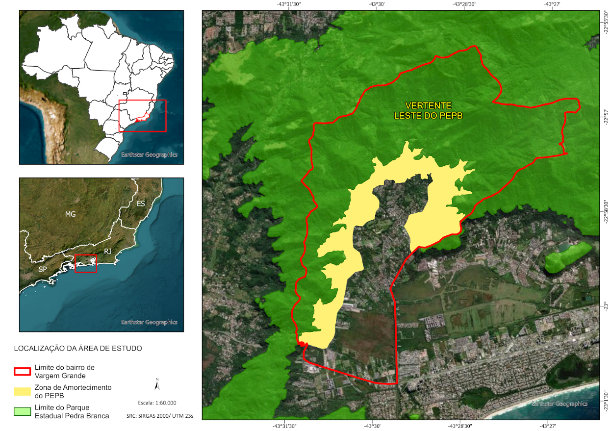
Figure 1: Location map of the study area and its relationship with the PEPB.
Source: Caroline Guedes, 2024
Geographic Characterization of the Study Area
The formalization of neighborhoods, consolidated by Municipal Decree No. 3,158 of 1981, structured and delimited Vargem Grande and other areas of the Baixada region after centuries of agricultural cycles and territorial transformations. However, population growth and urban expansion have intensified territorial conflicts, particularly regarding access to and use of green areas and environmental preservation zones, such as the Pedra Branca State Park (PEPB), demonstrating that social dynamics, territorial appropriation, and landscape changes continue to significantly influence the neighborhood.
3.1 Context of Urban Expansion in the Vargem Grande Neighborhood
Historically, the Vargem Grande neighborhood, located in the Jacarepaguá Lowlands, has undergone profound territorial and urban transformations. Since the implementation of the Vargens Urban Structuring Project (PEU das Vargens – Complementary Law 104/2009), extended until 2013, the region has experienced an intense process of urbanization and population densification. Concurrently, the Municipal Master Plan (2011) classified the neighborhood as an Area of Special Urban Interest, amplifying the influence of urban expansion, even though the PEU was approved without public consultation or an environmental feasibility study, contravening the City Statute (Name, 2010). According to IBGE Census data, the population was 14,039 inhabitants in 2010 and increased to 21,350 inhabitants in 2022.
Urban expansion in the Jacarepaguá Lowlands was driven by major infrastructure projects during Mayor Eduardo Paes's first term (2009-2012), including the implementation of the Transoeste BRT, the duplication of Avenida das Américas, and the opening of the Grota Funda tunnel. These projects increased land value and intensified real estate pressure, rapidly transforming semi-rural areas into new residential developments (Oliveira et al., 2019; Faulhaber, 2016), thereby demonstrating a radical modification of the landscape. This dynamic resulted in gentrification, increased land costs, and the displacement of low-income populations, especially near the Pedra Branca State Park (PEPB), generating conflicts over access to and use of green areas (Name, 2010; Oliveira; Fernandes, 2020). In the specific context of Vargem Grande, the neighborhood became a priority target for the real estate sector, driven by the Vargens Urban Structuring Project (PEU) (Faulhaber, 2016).
In this context of accelerated urbanization and real estate speculation, the situation in Vargem Grande became particularly concerning due to the presence of the Pedra Branca State Park (PEPB), one of the largest Atlantic Forest conservation units in Brazil, located on its boundary. Recognized as one of the largest urban forests in the world and the largest in the country, the PEPB covers approximately 58% of the neighborhood's area and is extremely important for the hydrological and climatic balance of the city of Rio de Janeiro (Turetta et al., 2023).
The growing occupation, intensified by the Vargens PEU and the guidelines of the 2011 Municipal Master Plan, resulted in a significant increase in urban densification and local population. This transformation has caused substantial changes in the landscape, raising serious concerns regarding the environmental quality of the Park and its surroundings. In this sense, the PEPB's Buffer Zone (BZ), which represents about 31% of the total park area within the neighborhood, acts as a "buffer area," and its preservation is essential to mitigate external impacts and protect the Park's ecological integrity from the challenges posed by urbanization (Costa et al., 2006).
Real estate capital, supported by public authorities, has promoted the appreciation of the territory, often incorporating fragments of remaining ecosystems as attractions for high-standard developments, while lower-income areas experience precariousness and devaluation (Montezuma, 2020; Cardeman, 2014). Despite the classification of priority areas with urban restrictions by the Rio de Janeiro City Master Plan (PLC 229/2021), urban growth continues to pressure local infrastructure, including drainage, transportation, and basic services, highlighting the need for urban planning that contemplates environmental and social sustainability, in addition to mitigating territorial conflicts in the Park's buffer zone.
3.2 Territorial Disputes: The Fragmentation of the Landscape in Vargem Grande
As territorial disputes in the Vargem Grande neighborhood intensify, the environmental pressure caused by real estate growth and public authority actions imposes significant challenges on local farmers. The situation of farmers in the struggle for this territorial dispute in Vargem Grande can be summarized in the following passage:
The locality has been undergoing changes in its traditional agricultural activities, generating a true identity crisis in the region and economic instability for farming families. Based on an urban expansion tied to capital, the proposed territorialization occupies physical space through the embodiment of the speculative market, with the participation of public authorities sponsoring the necessary infrastructure for the expansion and profit of construction companies." (Baptista et al., 2020, p. 121)
This pressure manifests in the reconfiguration of space that fragments the landscape, which contradicts traditional occupation by promoting an "environmental protection" that, in practice, serves urban expansion. This reconfiguration, however, ends up being accelerated (or is intensified), as reinforced in the following passage:
On one side, public agents alter current legislation, deterritorializing environmental conservation areas, transforming them into new territory with the costs of real estate speculation. On the other side, there is fierce defense for the implementation of full environmental conservation units, excluding traditional farmers from their ways of life reproduction. (Baptista et al., 2020, p. 119)
According to the text of the Participatory Cartography of the Carfundá-Astrogilda Quilombo in Vargem Grande, organized by AS-PTA Family Farming and Agroecology (2022), agriculture was, for many years, the main livelihood of Vargem Grande residents, establishing a deep and identity-forming bond with the landscape of the Pedra Branca Massif. However, the local agricultural population lives with constant uncertainties and conflicts. Their activities are affected by strict environmental regulations, which, although aimed at protecting the park, end up complicating daily life and imposing numerous challenges on farmers, as described below:
Farmers residing within the boundaries of the Pedra Branca State Park (PEPB) face restrictions imposed by the State Environmental Institute (INEA). These limitations affect cultivation, the construction and renovation of their homes, and cause difficulties in accessing basic services, such as water supply, sewage treatment, garbage collection, and connection to the electrical grid. The territory they occupy is marked by challenges, ambiguities, and constant tensions." (Oliveira, 2020, p. 11).
Thus, the advancement of urbanization in the study area establishes a cycle of landscape fragmentation and intense territorial disputes. The rapid real estate expansion, driven by infrastructure projects, directly collides with traditional forms of occupation and the imperatives of environmental conservation. This dynamic negatively impacts the Vargem Grande neighborhood, stripping it of its semi-rural characterization, pressuring local farmers, and consequently, critically affecting the Pedra Branca State Park (PEPB), the largest conservation unit within its boundaries. The fragmentation of the landscape not only threatens the Park's biodiversity by isolating ecosystems but also calls into question the effectiveness of environmental protection, transforming the area into a frontline of conflict between development and preservation.
Materials and Methods
The recognition of the study area and the preliminary analysis of land use and cover changes were conducted using Google Earth Pro software, through the satellite image history feature (period from 2012 to 2022).
Subsequent analytical development utilized QGIS (version 3.26.3), an open-source Geographic Information System (GIS), for Digital Image Processing (DIP) and raster data manipulation. ArcGIS Pro (version 3.3.1, via educational license) was used for vector data processing and, primarily, for the final elaboration and design of cartographic layouts (legends, scales, and titles).
All cartographic products were referenced to the SIRGAS 2000 Geodetic Reference System, with the Projected Coordinate System UTM Zone 23S (EPSG:31983). The research followed the methodological flowchart presented in Figure 2.
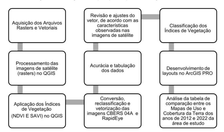
Figure 2: Flowchart of the main methodological steps used in the research.
Source: Caroline Guedes, 2024
4.1 Flow of Geoprocessing Techniques Employed
The adopted methodology was based on the Integrated Analysis of Geotechnologies, aiming to investigate the landscape dynamics in the sector of the Pedra Branca State Park (PEPB) and its Buffer Zone (BZ) within the Vargem Grande neighborhood, over the period from 2012 to 2022.
4.1.1 Acquisition of Vector and Raster Data
Vector data concerning administrative boundaries (neighborhoods) and protected areas were obtained from the official open data portal of the Rio de Janeiro municipality (DATA.RIO). The raster base consisted of medium and high spatial resolution satellite images, selected for the extreme years of the time series to allow comparative analysis of land use and cover transformations.
For the year 2012, images from the RapidEye satellite were used, with a spatial resolution of 5 meters, resampled from the orthorectified, level 3A images made available through the GeoCatalog of the Ministry of the Environment (MMA). Mapping was performed from the composition of bands 3 (red) and 5 (near-infrared), suitable for discriminating vegetation cover, adopting a mapping scale compatible with the image resolution (1:10,000).
For the year 2022, images from the CBERS-04A satellite were used, with a spatial resolution of 2 meters, provided by the National Institute for Space Research (INPE), utilizing bands 3 (red) and 4 (near-infrared). The mapping scale adopted for this year was 1:10,000, compatible with the level of detail provided by the image.
The preliminary identification of land use and cover classes was performed through visual inspection in Google Earth Pro software, using the historical image feature for the interval from 2012 to 2022. This stage aimed to recognize areas representative of the different classes, based on visual patterns, textures, and spectral characteristics consistent throughout the time series, supporting the interpretation and validation of thematic mapping.
For determining the classes, the official scheme of the Rio de Janeiro State Secretariat of the Environment was adopted, according to the guidelines established in Technical Note No. 41 – Methodological Procedures for Mapping Vegetation Cover and Land Use in the Municipality of Rio de Janeiro, which follows the codifications and standards defined by the Land Use Technical Manual (IBGE, 2013), ensuring terminological standardization and cartographic compatibility with official mappings. Additionally, a comparison was made with classes previously mapped for the year 2018, available on the municipal data portal (DATA.RIO), as a reference and for verification of result consistency.
4.1.2 Processing of Satellite Images in QGIS
The choice of satellite images and the use of DIP techniques were fundamental for detailing vegetation conditions, overcoming the limitations of conventional mapping provided by the City Hall. Image preprocessing included:
- Mosaic composition of the RapidEye images from 2012 (days September 15 and 18), using the QGIS "Miscellaneous / Merge" tool to unify the scenes in the NIR and Red bands (vegetation indices) and RGB (classification);
- Contrast correction, with rendering by "Local Cumulative Stretch" for visual enhancement;
- Reprojection of the mosaics (originally in WGS 84 / UTM Zone 23S) to the SIRGAS 2000 / UTM Zone 23S system (EPSG:31983);
- Clipping of the rasters, using the boundaries of the PEPB and its BZ as a mask, ensuring precise delimitation of the area of interest.
4.1.3 Application and Classification of Vegetation Indices in QGIS
Digital Image Processing (DIP) included, after preprocessing, the calculation of the NDVI and SAVI vegetation indices (for 2012 and 2022) using the QGIS Raster Calculator. The results were classified into four vegetation vigor classes for comparative temporal analysis.
The 2022 Land Use and Cover Mapping was performed by semi-automatic classification (Dzetsaka plugin – Random Forest), reclassifying the raster into six land use categories. The result was converted to vector format (polygon) for area calculation and refinement. Classification accuracy was assessed using the Kappa Index and Overall Accuracy (r.kappa).
The mapping for the year 2012 used pre-existing vector data provided by the City Hall. Finally, all index maps and land use and cover maps were finalized in ArcGIS Pro (student license), standardized according to the SIRGAS 2000 / UTM Zone 23S Reference System (EPSG:31983), and organized into comparative cartographic layouts, aiming at the analysis of landscape transformations.
4.2 Methodological Justification
Considering the diversity of procedures adopted and the inherent complexity of the environmental dynamics in Vargem Grande, it is relevant to justify the choice of tools employed. Faced with this complexity, especially in an interface area between urban expansion and conservation units, the methodology required the use of high-precision instruments with analytical capability. In this sense, Remote Sensing (RS), Digital Image Processing (DIP), and Geographic Information Systems (GIS) were mobilized as the essential technological triad for capturing, processing, and analyzing land use and cover changes over the study period (2012–2022). Such geotechnologies allowed not only for the quantification of changes but also for the detailed investigation of specific indicators of vegetation health and vigor, providing the basis for a precise understanding of socio-environmental pressures on the territory.
In this context, the use of Remote Sensing and satellite imagery proved fundamental for identifying, monitoring, and evaluating the socio-environmental impacts resulting from landscape transformations in the Vargem Grande neighborhood. It is from this perspective, which recognizes the relevance of the Pedra Branca State Park (PEPB) and the urban pressures exerted on its surroundings, that the present study delves deeper. The focus fell on the assessment of vegetation loss and landscape modifications, through indicators derived from remote sensing, applied via geoprocessing techniques such as the Normalized Difference Vegetation Index (NDVI) and the Soil-Adjusted Vegetation Index (SAVI). These metrics enabled more precise vegetation monitoring and contributed to a detailed understanding of environmental dynamics and, consequently, of landscape transformations in the studied area.
Results and Discussions
For mapping the study area, two distinct sources were used. The 2012 situation (Figure 3) was established based on land use and cover polygons available on the Rio de Janeiro City Hall's open data portal (DATA RIO), and this official mapping served as the basis for comparison in this research analysis. In contrast, the map for 2022 (Figure 4) was developed specifically for the portion of the Pedra Branca State Park (PEPB) and its buffer zone within the Vargem Grande neighborhood. This more recent mapping was generated from the supervised classification of satellite images (from CEBERS 04A), using digital image processing (DIP) techniques.
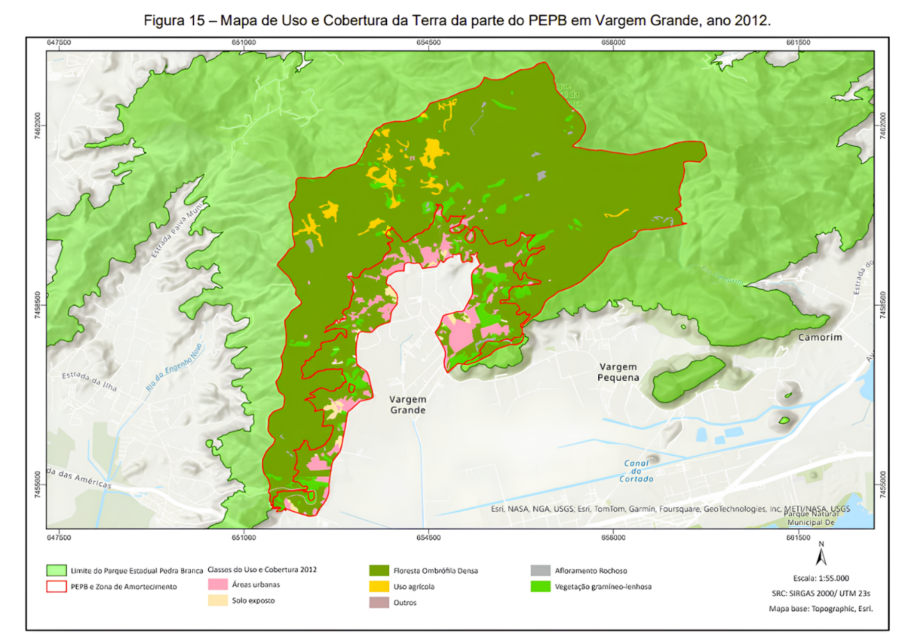
Figure 3: Land Use and Cover Map of the PEPB portion in Vargem Grande, year 2012.
Source of secondary data: DATA RIO. Source of primary data: classified RapidEye images. Source: Caroline Guedes, 2024
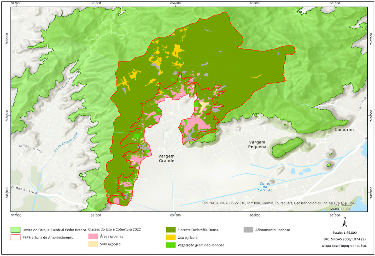
Figure 4: Land Use and Cover Map of the PEPB portion in Vargem Grande, year 2022.
Source of secondary data: DATA RIO; Source of primary data: CBERS 04A images classified by Caroline Guedes, 2024
The comparative analysis of the Land Use and Cover maps between 2012 and 2022 (Tables 1 and 2, respectively) revealed significant transformations in the landscape of the Pedra Branca State Park region and its buffer zone, specifically in the Vargem Grande neighborhood.
In 2012, Dense Ombrophilous Forest dominated (86.03%), followed by urban areas (5.18%), concentrated in the Buffer Zone, and agricultural use (2.35%). Other minor classes included bare soil (0.96%), grass-woody vegetation (4.85%), rock outcrop (0.50%), and "others" (0.04%). In 2022, Dense Ombrophilous Forest remained predominant and even expanded slightly (87.25%). The most notable change occurred in urban areas, which increased to 6.35% of the total area, reflecting expansion, mainly around the buffer zone. Agricultural use remained stable (2.55%). There was also a significant growth in rock outcrop (from 0.50% to 2.10%), although this change may be related to classification issues (confusion matrix). Grass-woody vegetation decreased (from 4.85% to 1.05%), while the bare soil class also decreased (0.26%).
Table 1: Quantitative overview of Land Use and Cover classes in the study area for the year 2012
Classes | Area (km²) | % of area (km²) |
Dense Ombrophilous Forest | 25,70 | 86,03 |
Urban Areas | 1,54 | 5,18 |
Agricultural Use | 0,70 | 2,35 |
Bare Soil | 0,28 | 0,96 |
Rock Outcrop | 0,15 | 0,50 |
Grass-Woody Vegetation | 1,45 | 4,85 |
Others | 0,01 | 0,04 |
Source: Caroline Guedes, 2024
Table 2: Quantitative overview of Land Use and Cover classes in the study area for the year 2022
Classes | Area (km²) | % of area (km²) |
Dense Ombrophilous Forest | 26,06 | 87,25 |
Urban Areas | 1,90 | 6,35 |
Agricultural Use | 0,76 | 2,55 |
Bare Soil | 0,21 | 0,70 |
Rock Outcrop | 0,62 | 2,10 |
Grass-Woody Vegetation | 0,31 | 1,05 |
Others | N/A | N/A |
Source: Caroline Guedes, 2024
In summary, the Land Use and Cover analysis demonstrates that Vargem Grande and its buffer zone underwent notable and visible transformations in the landscape (Figure 5). These changes are especially evident due to the increase in urban area, which resulted in vegetation suppression and directly impacted the landscape configuration.
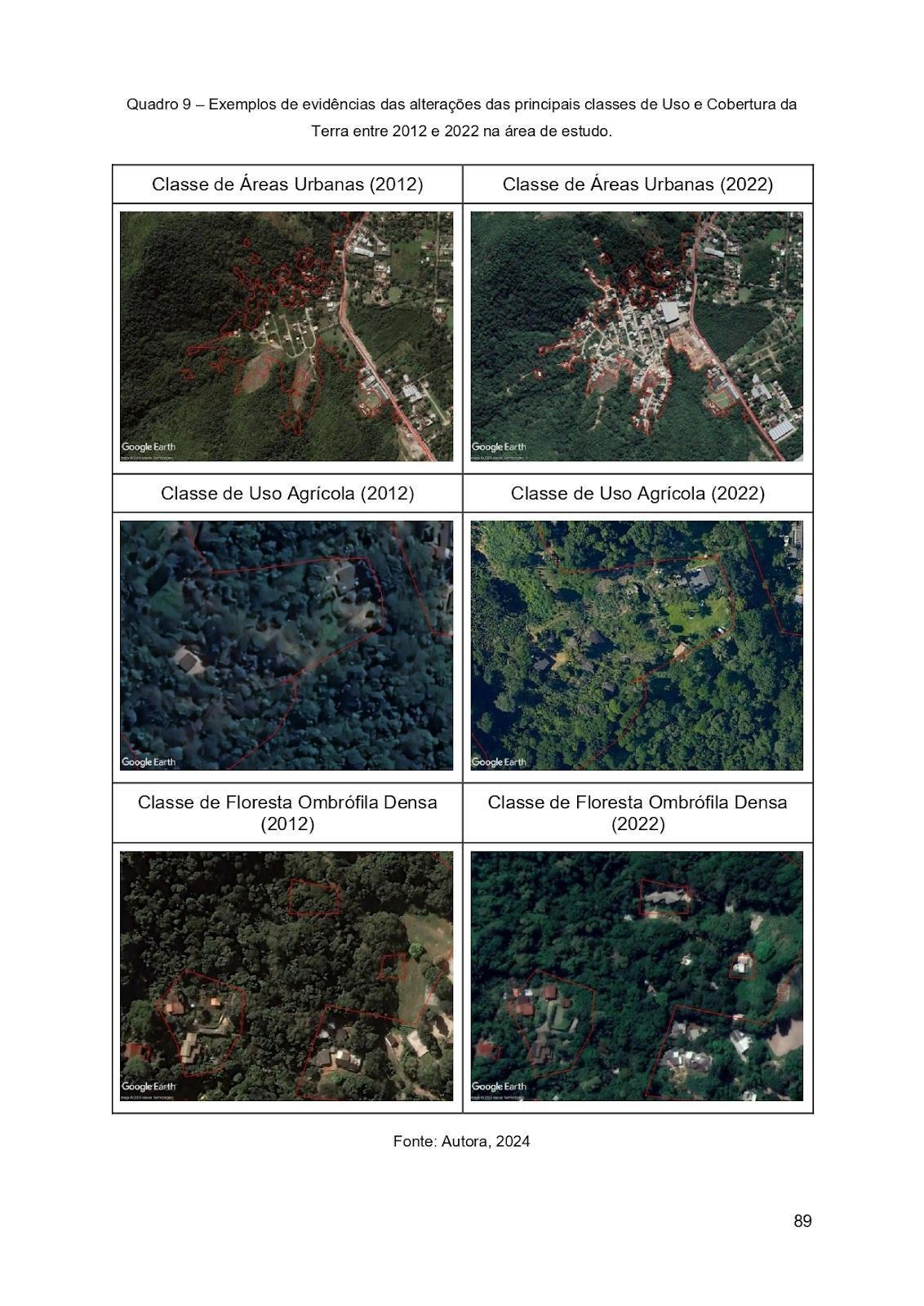
Figure 5: Comparative Analysis of Land Use and Cover Classes: Evidence of Landscape Changes (2012–2022).
Source: Caroline Guedes, 2024
5.1 Analysis of NDVI and SAVI for the Total Study Area
The results presented in tables 3 and 4, which compare the years 2012 and 2022, provide an analysis of land use and cover change, as well as landscape change in the studied area. This comparison was based on vegetation indices, the NDVI (Normalized Difference Vegetation Index) and the SAVI (Soil Adjusted Vegetation Index). The combined use of these indices allowed for a detailed assessment of changes in vegetation cover and the advance of urbanized areas over the decade, highlighting significant transformations that occurred during the period.
Table 3: Interpretation of NDVI and SAVI classification for the year 2012
Classes | NDVI | SAVI |
Dense Vegetation | 0,80 | 0,91 |
Sparse Vegetation | 0,30 | 0,49 |
Urbanized Area | 0,10 | 0,07 |
Absence of Vegetation | -0,27 | -0,34 |
Source: Caroline Guedes, 2024
Table 4: Interpretation of NDVI and SAVI classification for the year 2022
Classes
Classes | NDVI | SAVI |
Dense Vegetation | 0,80 | 1,00 |
Sparse Vegetation | 0,45 | 0,55 |
Urbanized Area | 0,15 | 0,02 |
Absence of Vegetation | -0,10 | -0,13 |
Source: Caroline Guedes, 2024
The comparative analysis of the NDVI and SAVI vegetation indices between 2012 and 2022 (Figures 6 to 9) revealed a landscape change dynamic marked by a contrast between vegetation regeneration and urban advancement. Regarding dense vegetation, the extent of the areas remained stable (NDVI constant at 0.8); however, the increase in SAVI (from 0.91 to 1.0) indicated an improvement in quality and density, suggesting healthier vegetation with less interference from bare soil.
Regarding sparse (grass-woody) vegetation, an improvement in the indices was observed, with NDVI rising from 0.30 to 0.45 and SAVI from 0.49 to 0.55. This pointed to moderate densification, which may be the result of natural regeneration processes or environmental recovery efforts in the analyzed area. Additionally, in areas characterized by the absence of vegetation, the increase in both indices (NDVI from -0.27 to -0.10 and SAVI from -0.34 to -0.13) indicated a partial recovery of vegetation cover where vegetation suppression was almost total.
On the other hand, the process of urban expansion altered the landscape. Although urbanized areas showed a slight increase in NDVI (from 0.10 to 0.15), SAVI decreased significantly (from 0.07 to 0.02), indicating an even greater reduction in vegetation presence.
In summary, the analysis of data from the total study area revealed a landscape dynamic with a dual contrast. On one hand, there is a positive trend of recovery and densification of vegetation in natural areas. On the other, vegetation suppression persists, being more notable in the boundary perimeters between the neighborhood and the park, a direct indicator of urban expansion. This complex interaction between conservation and expansion processes highlights the importance of balancing development with environmental preservation, especially in conservation units under the strict protection category like the PEPB.
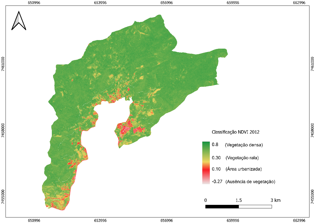
Figure 6: NDVI of the PEPB portion within the Vargem Grande neighborhood, for the year 2012.
Source: Caroline Guedes, 2024

Figure 7: NDVI of the PEPB portion within the Vargem Grande neighborhood, for the year 2022.
Source: Caroline Guedes, 2024
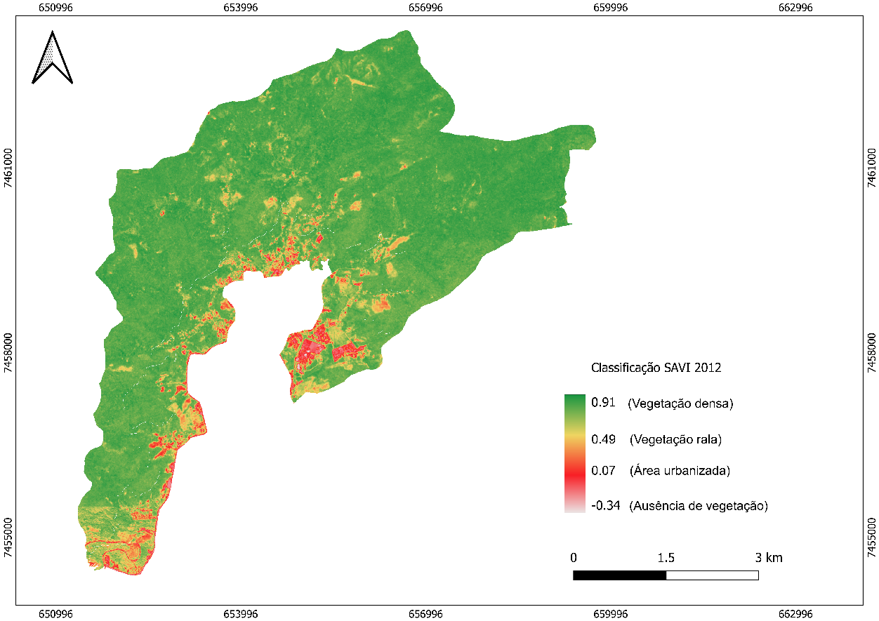 Figure 8: SAVI of the PEPB portion within the Vargem Grande neighborhood, for the year 2012.
Source: Caroline Guedes, 2024
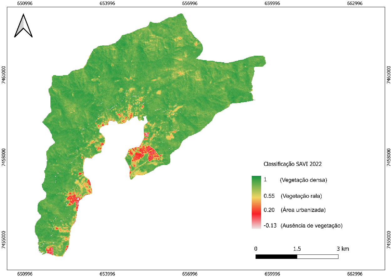 Figure 9: SAVI of the PEPB portion within the Vargem Grande neighborhood, for the year 2022.
Source: Caroline Guedes, 2024
5.2 Analysis of NDVI and SAVI of the PEPB Buffer Zone
Just as in the comparative analysis of indices conducted for the general area, tables 5 and 6 present an analysis focused on the PEPB buffer zone, comparing the years 2012 and 2022. This comparison, based on the NDVI and SAVI vegetation indices, proved fundamental, as it aimed to reveal primarily the changes in land use and cover, as well as the change in landscape dynamics in the immediate vicinity of the Conservation Unit.
Table 5: Interpretation of NDVI and SAVI classification for the year 2012
Classes | NDVI | SAVI |
Dense Vegetation | 0,71 | 0,89 |
Sparse Vegetation | 0,37 | 0,48 |
Urbanized Area | 0,20 | 0,03 |
Absence of Vegetation | -0,25 | -0,32 |
Source: Caroline Guedes, 2024
Table 6: Interpretation of NDVI and SAVI classification for the year 2022
Classes | NDVI | SAVI |
Dense Vegetation | 0,80 | 1 |
Sparse Vegetation | 0,45 | 0,58 |
Urbanized Area | 0,10 | 0,02 |
Absence of Vegetation | -0,10 | -0,13 |
Source: Caroline Guedes, 2024
The comparative analysis of vegetation indices in the Buffer Zone of the Pedra Branca State Park, between 2012 and 2022 (Figures 10 to 13), also revealed a duality in landscape change, as was also observed in the total area. Regarding dense vegetation, the indices point to a notable improvement or preservation, despite the present urban pressure. The NDVI increased from 0.71 to 0.80, and SAVI reached the maximum value of 1.0, suggesting that this vegetation became healthier and denser. Areas of sparse vegetation also showed positive signs; NDVI rose from 0.37 to 0.45 and SAVI from 0.48 to 0.58, indicating slight recovery or stabilization, possibly due to natural regeneration in transition areas.
In contrast, in urbanized areas, the expansion of land use and cover is evident, with a decrease in both NDVI (from 0.20 to 0.10) and SAVI (from 0.03 to 0.02). This decline confirms the reduction of vegetation cover, reinforcing the advance of urban occupation over the Buffer Zone limits. In summary, the PEPB's BZ demonstrated resilience of native vegetation, which densifies and maintains itself in some locations, while at the same time vegetation suppression caused by urban expansion intensified in its perimeters.
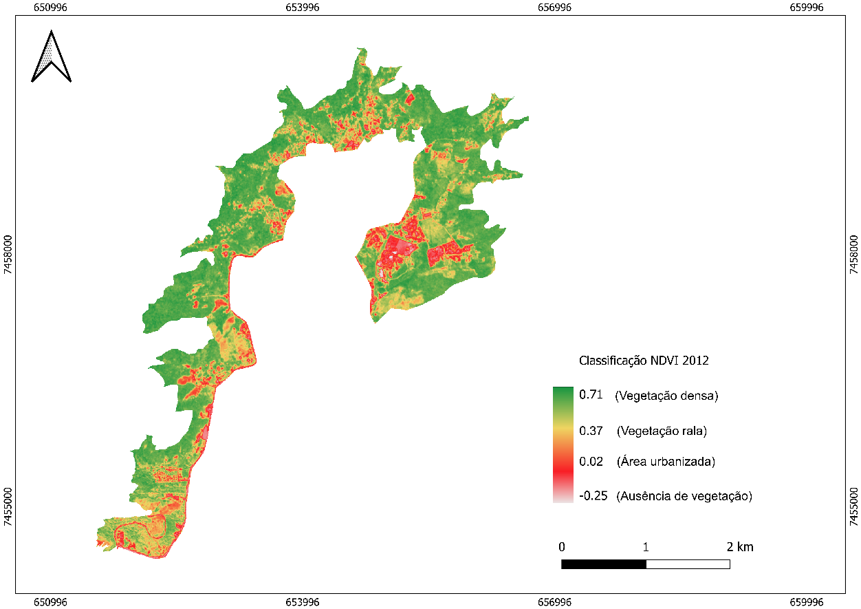
Figure 10: NDVI of the PEPB BZ, for the year 2012.
Source: Caroline Guedes, 2024
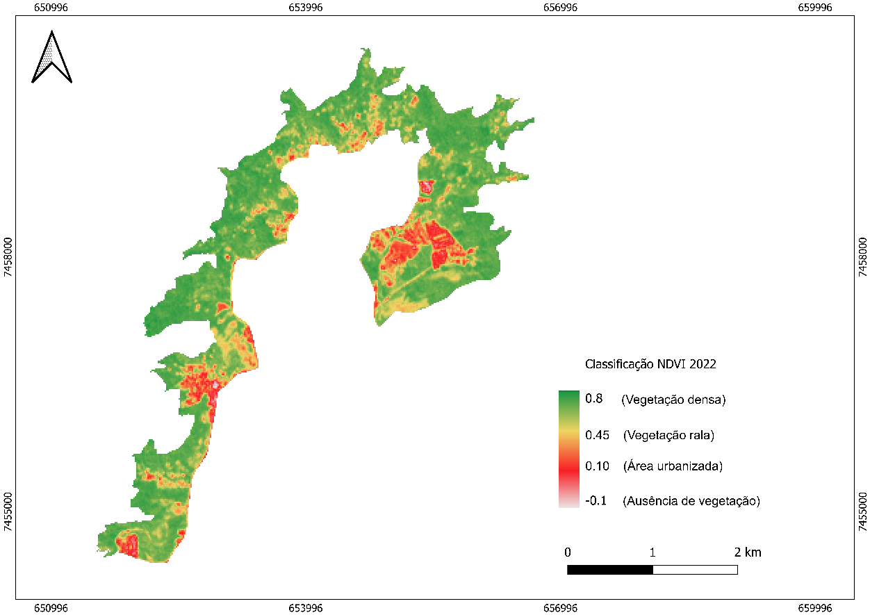 Figure 11: NDVI of the PEPB BZ, for the year 2022.
Source: Caroline Guedes, 2024
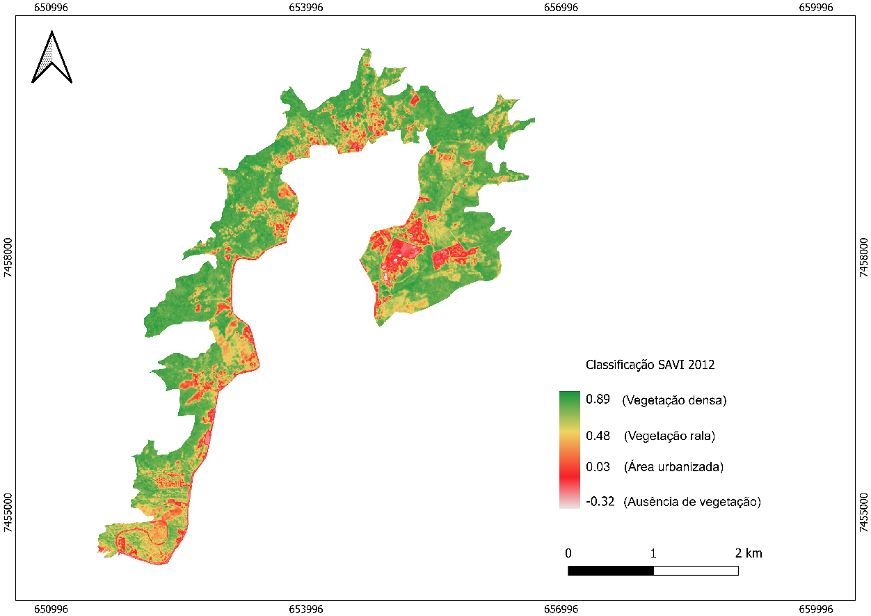
Figure 12: SAVI of the PEPB BZ, for the year 2012.
Source: Caroline Guedes, 2024
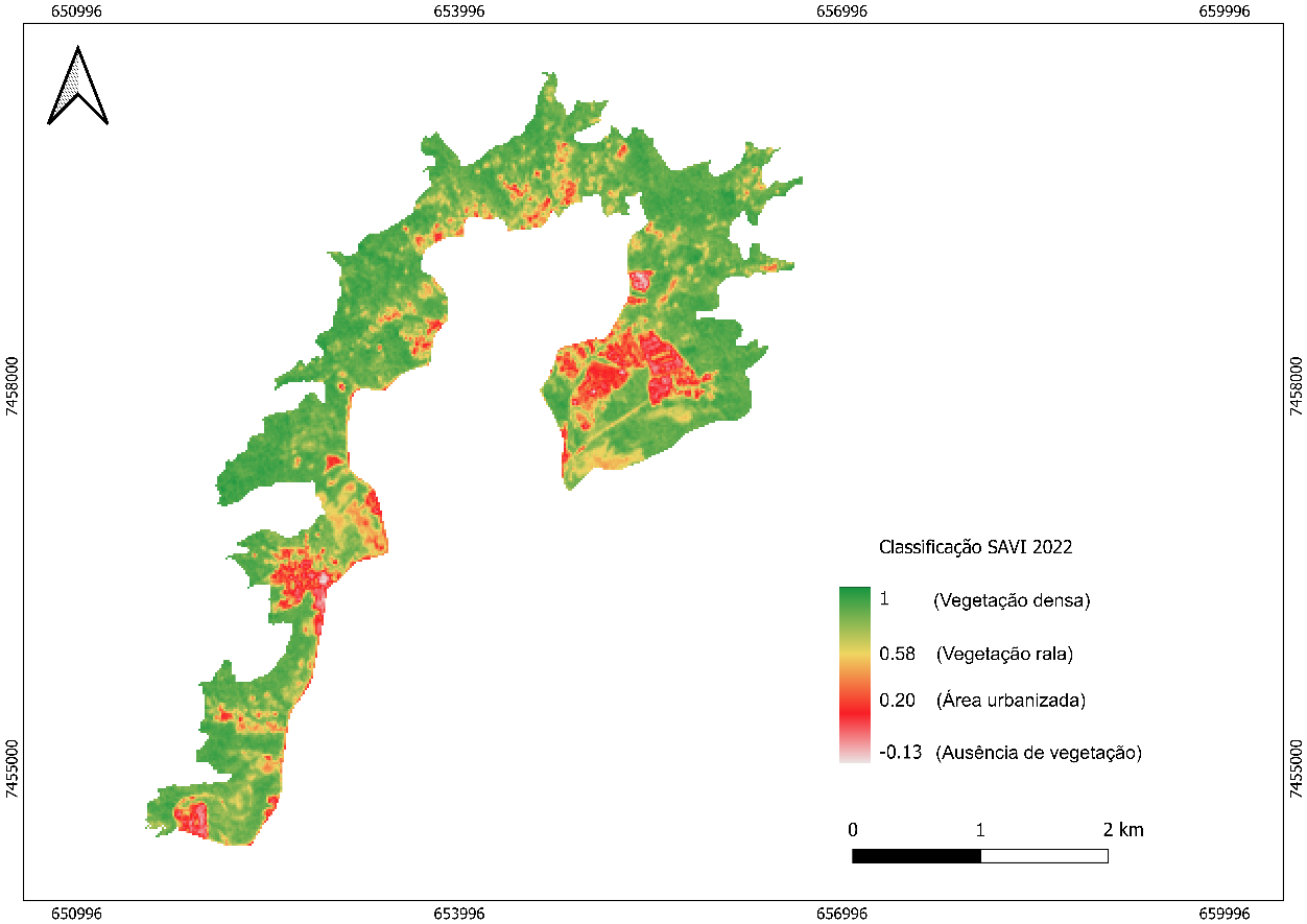
Figure 13: SAVI of the PEPB BZ, for the year 2022.
Source: Caroline Guedes, 2024
Final Considerations
This research demonstrated that, between 2012 and 2022, urban expansion in the region was significant and, if maintained in a disorderly manner, threatens forest fragments and vegetation cover, generating socio-environmental conflicts and marginalizing communities of small farmers and traditional groups, such as quilombos, creating a scenario that can be interpreted as "environmental injustice and racism" (Rocha, 2022). This pressure is reflected by the decrease in vegetation, evidenced by the NDVI and SAVI indices, and is aggravated by the absence of urban planning and effective public policies. For more balanced development, it is crucial to strengthen public policies that integrate environmental conservation and local socio-economic needs, with the effective application of legislations such as the SNUC, the PNEA, and the promotion of agroecology, in addition to the adoption of participatory planning.
The scenario, however, is influenced by regulatory measures and the actions of governmental agencies. The new Master Plan (PLC No. 44/2021) proposes important improvements for the Vargens region, now protected by the newly created APA do Sertão Carioca, suggesting a reduction in building indices to promote sustainability. Environmental management in the Rio de Janeiro Metropolitan Region depends on the coordination between agencies such as INEA, responsible for mapping and monitoring vegetation cover in Conservation Units (CUs), and the Rio de Janeiro City Hall (via IPP and the Municipal Secretariat of the Environment), essential for urban planning, environmental licensing, and updating the Master Plan.
However, the effectiveness of this management is compromised by the lack of transparency in the dissemination of updated georeferenced data by the City Hall, hindering researchers' and academics' access to crucial information about vegetation. This deficiency forces academia to resort to more complex methods, such as high-resolution satellite images (for example, the RapidEye satellite), although the continuity of the CBERS mission is making more recent data (CBERS 4A) more accessible and excellent for NDVI mapping, as it provides essential multispectral bands (red and near-infrared) through its sensors, such as WFI and MUX, allowing for use in software like QGIS or Global Mapper. It is urgent to conduct more studies on land use and occupation in the West Zone of Rio de Janeiro, a region under intense real estate pressure (aggravated by events like the Olympics and Rock in Rio) and by the actions of parallel powers (militias), which build illegally in fragile areas, impacting the ecosystem.
In addition to the presented results, it is noteworthy that the analysis of territorial dynamics could be deepened through the incorporation of additional geoprocessing techniques capable of expanding the understanding of ongoing environmental and urban processes. Methods such as object-based image analysis (OBIA), more extensive multitemporal analyses, continuous historical series with NDVI/SAVI, and machine learning-based change detection would allow for the identification of spatial patterns, prediction of occupation trends, and assessment of future pressure scenarios on the Pedra Branca State Park. Products derived from MapBiomas, which has been using Sentinel-2 (despite having a spatial resolution of 10 m in the 4 bands, including NIR, it has broad global coverage with a revisit frequency of 5 days with the two satellites, Sentinel-2A and 2B), would also enrich the structural analysis of vegetation and land cover changes. Thus, it is reinforced that advances in geotechnologies offer promising paths for more detailed investigations into urban expansion and its socio-environmental impacts, expanding diagnostic capacity and contributing to more effective decisions in territorial planning.
In conclusion, to address these challenges and ensure a fairer and more sustainable land use in the Vargem Grande neighborhood, it is essential that the research results, which reflect the loss of vegetation cover and disorderly urban expansion, inform territorial planning. This requires the strengthening of environmental policies (SNUC, PNEA) and the engagement of society in participatory planning. Fundamentally, the effectiveness of management depends on transparent coordination between agencies such as INEA and the City Hall, making it urgent to overcome the lack of updated georeferenced data on the part of public authorities. Only with transparency and participation will it be possible to mitigate real estate pressure and the actions of parallel powers on the environmentally fragile areas of Vargem Grande and its surroundings, ensuring the conservation of the Pedra Branca State Park.
References
BAPTISTA, S. R. N. et al. Sertão carioca: a construção social de um território agroecológico. In: OLIVEIRA, Rogério; FERNANDEZ, Annelise (orgs.). Paisagens do sertão carioca: floresta e cidade. Rio de Janeiro: PUC-Rio, 2020. p. 119-145. Available at: https://www.editora.puc-rio.br/media/Paisagens_do_sertao_carioca%20(1).pdf. Accessed on: 25 de may 2025.
CARDENAM, R. G. A transformação da paisagem em área de expansão urbana: planejamento em Vargem Grande no Rio de Janeiro. Tese (Doutorado) — PROARQ, Programa de Pós-Graduação em Arquitetura, Universidade Federal do Rio de Janeiro, 2014. Available at: http://objdig.ufrj.br/21/teses/824704.pdf. Accessed on: 25 jan. 2024.
CASISMIRO, P. C. Geografia, ecologia da paisagem e teledetecção: enquadramento-contextualização. Geografia: Revista da Faculdade de Letras da Universidade do Porto, v. 19 [s/n/]. 2003 Available at: https://scholar.google.com/citations?view_op=view_citation&hl=pt-PT&user=6mbY_uEAAAAJ&citation_for_view=6mbY_uEAAAAJ:W7OEmFMy1HYC. Accessed on: 09 may 2024.
COSTA, Nadja Maria Castilho et al. SIGNIFICADO E IMPORTÂNCIA DA ZONA DE AMORTECIMENTO DE UNIDADES DE CONSERVAÇÃO URBANAS: O EXEMPLO DO ENTORNO DAS ÁREAS LEGALMENTE PROTEGIDAS DA CIDADE DO RIO DE JANEIRO. Geo UERJ, Rio de Janeiro, v. 1, n. 17, p. 95 à 104, 2011. Available at: https://www.e-publicacoes.uerj.br/geouerj/article/view/1298. Accessed on: 20 mar. 2025.
FAULHABER, L. Jogo imobiliário carioca. Rio de Janeiro: UFRJ, 2016. Dissertação (Mestrado) - Universidade Federal do Rio de Janeiro, Instituto de Pesquisa e Planejamento Urbano e Regional, Programa de Pós-Graduação em Planejamento Urbano e Regional, 21 nov. 2016. Available at: http://objdig.ufrj.br/42/teses/864440.pdf. Accessed on: 18 aug. 2024.
GUEDES, Caroline Carneiro. Análise espaço temporal das transformações do uso e cobertura da terra do Parque Estadual da Pedra Branca e sua zona de amortecimento - bairro de Vargem Grande. 2024. 114 f. Monografia (bacharelado) - Universidade do Estado do Rio de Janeiro, Instituto de Geografia. Available at: https://catalogo-redesirius.uerj.br/TerminalWeb/acervo/detalhe/392648 . Accessed on: 05 aug. 2025.
MONTEZUMA, R.; OLIVEIRA, R. Os ecossistemas da Baixada de Jacarepaguá e o PEU das Vargens. Arquitextos, São Paulo, ano 10, n. 116.01, Vitruvius, jan. 2010. Available at: https://vitruvius.com.br/revistas/read/arquitextos/10.116/3385. Accessed on: 11 feb. 2024.
NAME, L. Análise da ocupação proposta pelo PEU das Vargens tendo como foco densidades, infraestruturas e condições ambientais. Arquitextos, São Paulo, ano 10, n. 116.01, Vitruvius, jan. 2010. Available at: https://vitruvius.com.br/revistas/read/arquitextos/10.116/3382. Accessed on: 27 jan. 2024.
OLIVEIRA, F. L. Planejando contra a corrente: o caso do Plano Popular das Vargens, Rio de Janeiro, RJ. In: ASSOCIAÇÃO NACIONAL DE PÓS-GRADUAÇÃO E PESQUISA EM PLANEJAMENTO URBANO E REGIONAL (ENAPUR). Anais do XVIII Encontro Nacional da Associação Nacional de Pós-Graduação e Pesquisa em Planejamento Urbano e Regional (ENAPUR). 2019.
OLIVEIRA, R. R. de; FERNANDEZ, A. C. F. (orgs.). Paisagens do sertão carioca: floresta e cidade. Rio de Janeiro: Editora PUC-Rio, 2020. Available at: https://www.editora.puc-rio.br/media/Paisagens_do_sertao_carioca%20(1).pdf. Accessed on: 13 aug. 2024.
RIO DE JANEIRO. Decreto nº 3.158, de 23 de julho de 1981. Estabelece a denominação, a codificação e a delimitação dos bairros da Cidade do Rio de Janeiro. Available at: http://leismunicipa.is/kbcvj. Accessed on: 05 mar. 2024.
RIO DE JANEIRO. Lei Complementar nº 104, de 27 de novembro de 2009. Institui o Projeto de Estruturação Urbana – PEU dos bairros de Vargem Grande, Vargem Pequena, Camorim e parte dos bairros do Recreio dos Bandeirantes, Barra da Tijuca e Jacarepaguá, nas XXIV e XVI Regiões Administrativas, integrantes das Unidades Espaciais de Planejamento números 46, 47, 40 e 45, e dá outras providências. Available at: https://e.camara.rj.gov.br/Arquivo/Documents/legislacao/html/C1042009.html. Accessed on: 05 mar. 2024.
RIO DE JANEIRO. Lei Complementar nº 111, de 1º de fevereiro de 2011. Dispõe sobre a Política Urbana e Ambiental do Município, institui o Plano Diretor de Desenvolvimento Urbano Sustentável do Município do Rio de Janeiro e dá outras providências. Autor: Poder Executivo. Available at: https://www.rio.rj.gov.br/dlstatic/10112/3678296/4353007/PlanoDiretorLC111_2011.PDF. Accessed on: 03 mar. 2024.
RIO DE JANEIRO. Lei Complementar nº 229, de 14 de julho de 2021. Institui o Programa Reviver Centro, que estabelece diretrizes para a requalificação urbana e ambiental, incentivos à conservação e reconversão das edificações existentes e à produção de unidades residenciais na área da II Região Administrativa – II R.A., bairros do Centro e Lapa, autoriza a realização de operação interligada e dá outras providências. (Vide regulamentação dada pelos Decretos nº 49.698/2021, nº 51.047/2022, nº 51.134/2022 e nº 54.109/2024). Available at: http://leismunicipa.is/ozdif. Acesso em: 25 sep. 2024.
ROCHA, F. A perspectiva racial do racismo ambiental: uma análise do conceito no brasil e a população sacrificada na zona oeste do rio de janeiro. Revista Da Associação Brasileira De Pesquisadores/as Negros/As (ABPN), v. 14, 121–140. 2022.
SANTOS, M. Metamorfoses do espaço habitado: fundamentos teóricos e metodológicos da geografia. São Paulo: Hucitec, 1988. Available at: https://geografiamb2.wordpress.com/wp-content/uploads/2009/03/metamorfose_do_espaco_habitado_-__milton_santos.pdf. Accessed on: 18 oct. 2025.
SECRETARIA MUNICIPAL DE MEIO AMBIENTE DO RIO DE JANEIRO. Nota Técnica nº 41: Procedimentos metodológicos para o mapeamento da cobertura vegetal e uso das terras do Município do Rio de Janeiro. Rio de Janeiro: Secretaria Municipal de Meio Ambiente do Rio de Janeiro. 2021. Available at: https://www.data.rio/documents/6740734d900b41ed90c79cf07687cff3/about. Accessed on: 03 mar. 2024.
TURETTA, A. P. Comunidades quilombolas do Maciço da Pedra Branca preservam o solo da maior floresta urbana do planeta e incrementam seus estoques de carbono do solo. Rio de Janeiro: Assessoria e Serviços a Projetos em Agricultura Alternativa, 2023. 8 p. Available at: https://www.infoteca.cnptia.embrapa.br/infoteca/bitstream/doc/1151520/1/Comunidades-quilombolas-do-Macico-da-Pedra-Branca-2023.pdf. Accessed on: 10 apr. 2024.
About the Authors
Caroline Carneiro Guedes holds a degree in Geography (Bachelor's) from the State University of Rio de Janeiro (UERJ) and works as a GIS Development Analyst. Throughout her academic and professional trajectory, she has accumulated experience in the area of scientific research, having participated as a volunteer in the UERJ Scientific Initiation Scholarship Program, in the project titled "Use of geotechnologies in the analysis of environmental vulnerabilities in nature conservation units," under the CNPq modality. Furthermore, she was part of the team for the Extension Project "DIG – A Proposal for the Dissemination of Geoprocessing in Geography," developed by the UERJ Institute of Geography. She was awarded the prize for best Undergraduate Thesis from the UERJ Institute of Geography in 2024, for the work titled "Spatio-temporal analysis of land use and cover transformations in the Pedra Branca State Park and its buffer zone – Vargem Grande neighborhood".
Vivian Castilho da Costa is an Associate Professor in the Department of Physical Geography at the Institute of Geography (IGEOG) of the State University of Rio de Janeiro (UERJ). She holds a Ph.D. in Geography from the Federal University of Rio de Janeiro (UFRJ) and has coordinated the Environmental Studies Group (GEA-UERJ) since 2020. She works in the field of Physical Geography, with an emphasis on geoprocessing, planning and management of protected areas, environmental risk, ecotourism, environmental education, and geoconservation. She develops research projects with a Prociência/UERJ grant since 2012 and supervises students in undergraduate programs and in the Stricto Sensu Graduate Program in Geography (Master's and Doctorate) at UERJ (PPGEO-UERJ), within the research line "Culture and Nature". She coordinates the Geoprocessing discipline for the Geography Licentiate course in the distance learning modality at UERJ (CEDERJ) and has been an editor of the Brazilian Journal of Ecotourism (RBEcotur) since 2010.
Author Contributions
Conceptualization, C.C.G.; methodology, C.C.G.; validation, C.C.G., V.C.C.; formal analysis, C.C.G.; investigation, C.C.G.; data curation, C.C.G., V.C.C.; writing — original draft preparation, C.C.G.; writing — review and editing, C.C.G., V.C.C.; visualization, C.C.G.; supervision, V.C.C. All authors have read and agreed to the published version of the manuscript.
Conflicts of Interest
The author declares no conflicts of interest.
About Coleção Estudos Cariocas
Coleção Estudos Cariocas (ISSN 1984-7203) is a publication dedicated to studies and research on the Municipality of Rio de Janeiro, affiliated with the Pereira Passos Institute (IPP) of the Rio de Janeiro City Hall.
Its objective is to disseminate technical and scientific production on topics related to the city of Rio de Janeiro, as well as its metropolitan connections and its role in regional, national, and international contexts. The collection is open to all researchers (whether municipal employees or not) and covers a wide range of fields — provided they partially or fully address the spatial scope of the city of Rio de Janeiro.
Articles must also align with the Institute’s objectives, which are:
- to promote and coordinate public intervention in the city’s urban space;
- to provide and integrate the activities of the city’s geographic, cartographic, monographic, and statistical information systems;
- to support the establishment of basic guidelines for the city’s socioeconomic development.
Special emphasis will be given to the articulation of the articles with the city's economic development proposal. Thus, it is expected that the multidisciplinary articles submitted to the journal will address the urban development needs of Rio de Janeiro.