
Volume 13 Issue 4 *Corresponding author leonardovb@poli.ufrj.br Submitted 10 Nov 2025 Accepted 8 Dec 2025 Published 26 Dec 2025 Citation FREIRES, L. H. C.; BARBALHO, L. V.; LIMA, F. R.. Transportation as a territorial driver: analysis of urban transformations in the city of Rio de Janeiro. Coleção Estudos Cariocas, v. 13, n. 4, 2025.
DOI: 10.71256/19847203.13.4.190.2025 The article was originally submitted in PORTUGUESE. Translations into other languages were reviewed and validated by the authors and the editorial team. Nevertheless, for the most accurate representation of the subject matter, readers are encouraged to consult the article in its original language.


| Transportation as a territorial driver: analysis of urban transformations in the city of Rio de Janeiro O transporte como indutor territorial: análise das transformações urbanas na cidade do Rio de Janeiro El transporte como inductor territorial: análisis de las transformaciones urbanas en la ciudad de Río de Janeiro Luiz Henrique de Carvalho Freires¹, Leonardo Vieira Barbalho²*
and Fernando Rodrigues Lima³ 1Universidade Federal do Rio de Janeiro, Av. Athos da Silveira Ramos, 149 – Cidade Universitária, Rio de Janeiro/RJ, CEP 21941-909, ORCID: 0009-0003-5887-4608, luizfreires@poli.ufrj.br 2Universidade Federal do Rio de Janeiro, Av. Athos da Silveira Ramos, 149 – Cidade Universitária, Rio de Janeiro/RJ, CEP 21941-909; Universitat Politècnica de València, Camí de Vera, s/n, 46022 València, España, ORCID: 0000-0003-2938-7934, leonardovb@poli.ufrj.br 3Universidade Federal do Rio de Janeiro, Av. Athos da Silveira Ramos, 149 – Cidade Universitária, Rio de Janeiro/RJ, CEP 21941-909,ORCID: 0000-0001-6244-1117, frlima@poli.ufrj.br
AbstractThe study examines the correlation between the expansion of public transport infrastructure and changes in land use and occupation in Rio de Janeiro from 2009 to 2019. The methodology employed spatial analysis in GIS, delineating the areas of influence of the Metro, BRT, and VLT systems. Cross-classification revealed that approximately 20% of the analyzed areas underwent significant modifications. The results indicate that the relationship between transport demand and territorial transformation is influenced by socio-spatial factors, highlighting the structuring role of transport and the need for integrated mobility and urban planning policies. Keywords: urban mobility, public transport, polycentrality ResumoO estudo analisa a correlação entre a expansão da infraestrutura de transporte público e as transformações no uso e ocupação do solo no Rio de Janeiro entre 2009 e 2019. A metodologia empregou análise espacial em SIG, com a delimitação das áreas de influência dos modais Metrô, BRT e VLT. A classificação cruzada indicou que cerca de 20% das áreas analisadas sofreram modificações relevantes. Os resultados apontam que a relação entre demanda e transformação territorial é influenciada por fatores socioespaciais e evidenciam o papel estruturador do transporte e a necessidade de políticas integradas de mobilidade e ordenamento urbano. Palavras-chave: mobilidade urbana, transporte público coletivo, policentralidade ResumenEl estudio analiza la correlación entre la expansión de la infraestructura de transporte público y las transformaciones en el uso y ocupación del suelo en Río de Janeiro entre 2009 y 2019. La metodología empleó análisis espacial en SIG, delimitando las áreas de influencia de los modos Metro, BRT y VLT. La clasificación cruzada indicó que aproximadamente el 20% de las áreas analizadas presentaron modificaciones relevantes. Los resultados muestran que la relación entre demanda y transformación territorial está influenciada por factores socioespaciales y evidencian el papel estructurador del transporte y la necesidad de políticas integradas de movilidad y ordenamiento urbano. Palabras clave: movilidad urbana, transporte público colectivo, policentralidad |
Introduction
Urban mobility constitutes one of the main contemporary challenges of large Brazilian metropolises, functioning as a structuring element of territorial development and a determinant of the population’s quality of life (Carvalho, 2016). The relationship between transport and land use, although widely recognized in the field of urban planning, still faces difficulties in effective implementation within municipal and metropolitan public policies (Lima Neto; Galindo, 2015).
In the Brazilian context, the enactment of Law No. 12,587/2012, which established the National Urban Mobility Policy (PNMU), represented an important regulatory milestone by setting guidelines for the integration between transport policies and land use. The Urban Mobility Plans (PMU), instruments provided for under this legislation, aim to guide mobility-related actions and investments in Brazilian municipalities with populations over 20,000 inhabitants. However, as demonstrated by Lima Neto and Galindo (2015), the effectiveness of these plans as public policy instruments remains limited, with low rates of preparation and implementation in legally obligated municipalities.
The Metropolitan Region of Rio de Janeiro (RMRJ) presents territorial and mobility characteristics that highlight the urgency of integrated policies (Silva, 2013). Historically structured in a monocentric manner, with a strong concentration of jobs and economic activities in the central core of the city of Rio de Janeiro, the region has experienced processes of polycentricity that modify travel patterns and generate new transport demands (Mello, 2019). Territorial occupation was historically enabled by public transport systems, initially streetcars and trains, which structured urban growth radially, connecting the suburbs to the center (Abreu, 2013).
Mello (2019) demonstrates that polycentricity in the RMRJ is intrinsically related to circulation and mobility patterns, since urban form and its repercussions directly impact travel time and distance. In monocentric structures, average home-to-work travel times and distances tend to be longer, especially for peripheral populations that lack proximity to the center. As new destinations consolidate, polycentricity emerges, creating differentiated travel demands and trips of a tangential nature, no longer exclusively radial.
With regard to the planning and financing of urban mobility in the RMRJ, Luft (2020) identifies a series of challenges related to metropolitan governance, the discontinuity of public policies, and the lack of integration among different federative levels. The author highlights the disarticulation among the various plans developed for the region, such as the Urban Transport Master Plan (PDTU-2015) and the Integrated Urban Development Strategic Plan (PEDUI-2018), which often represent conflicting interests and lack effective mechanisms for financing and implementation.
The issue of transfers within integrated public transport systems also deserves special attention. Studies on penalties associated with transfers show that the need for multiple transfers between transport modes negatively impacts the perceived quality of service and increases travel times, especially for peripheral populations that depend on the articulation between different modes to access employment opportunities and services (Cavalcanti et al., 2012). Physical, fare, and operational integration of transport systems therefore constitutes a fundamental element for the effectiveness of urban mobility policy.
Over the past decade and a half, Rio de Janeiro has undergone significant transformations in its public transport network, largely driven by mega-events hosted by the city, such as the 2014 World Cup and the 2016 Olympic Games. New transport modes were implemented, such as BRT (Bus Rapid Transit) and VLT (Light Rail Vehicle), in addition to the expansion of the metro network. These interventions, although expanding mass transit coverage, were carried out with limited consideration of their impacts on land use and occupation and without adequate coordination with urban development policies.
The municipality of Rio de Janeiro, as well as its entire metropolitan region, has a highly complex urban morphology (Barbalho et al., 2023), requiring transport planning that effectively keeps pace with territorial dynamics. The public transport network is extensive; however, it is not effective in many cases, which calls for historical investigation into how this factor has interfered with land use and the urban evolution of the municipality.
Accessibility provided by the implementation of new transport modes constitutes an essential factor for the emergence of new developments, altering land use and occupation in certain areas (Campos; Melo, 2005). In this context, it is essential to understand how recent modifications to the public transport system have influenced transformations in urban land use and occupation in the city of Rio de Janeiro.
1.1 Objectives
The general objective of this study is to analyze the correlation between transformations in land use and occupation and the expansion of transport infrastructure from 2009 to 2019, with an emphasis on the spatial distribution of stations and new transport modes (BRT, VLT, and Metro) as potential drivers of the emergence of new urban centralities.
1.2 Justification
The relevance of this study is grounded in multiple aspects. First, the integration between transport planning and land use constitutes a fundamental premise for sustainable urban development, as established both by the National Urban Mobility Policy (Law 12,587/2012) and by the Sustainable Urban Development Master Plan of Rio de Janeiro (Complementary Law 270/2024), as well as by the Municipal Sustainable Urban Mobility Plan (Rio Decree 45,781/2019).
Second, the effectiveness of Urban Mobility Plans as public policy instruments has been questioned by specialized literature (Lima Neto; Galindo, 2015), highlighting the need for studies that empirically assess the impacts of transport system interventions on territorial dynamics. The low rate of PMU implementation in Brazilian municipalities and the discontinuity of public policies point to the urgency of evidence demonstrating the importance of this integration.
Third, the metropolitan context of Rio de Janeiro, characterized by processes of polycentricity and significant socio-spatial inequalities (Mello, 2019), demands mobility policies that consider the diversity of travel patterns and territorial specificities. Understanding how public transport interventions affect land use can guide future policies that promote greater equity in access to urban opportunities.
Fourth, the challenges of planning and financing urban mobility in the RMRJ (Luft, 2020), including the disarticulation among different plans and the lack of integration across federative levels, reinforce the need for studies that provide technical input for more effective metropolitan governance and for the formulation of more cohesive and sustainable public policies.
Finally, the analyzed period (2009–2019) is particularly relevant because it encompasses transformations associated with mega-events and their urban legacies, allowing an assessment of the extent to which investments produced the expected territorial effects and whether they were accompanied by adequate land-use planning policies.
- Theoretical Framework
2.1 The Relationship between Transport and Land Use
In contemporary times, transport planning is composed of several statistical models that consider the interdependence between transport and land use in their formulation (Nigriello; Oliveira, 2013). Contemporary perspectives within urbanism tend to place transport in a fundamental position in urban planning (Melo, 2013).
Different aspects of land use generate different mobility demands within urban space. The provision of a given transport mode can directly interfere with the category of land use and occupation of a given area, since the accessibility enabled by transport is an essential factor for the location of various types of development (Campos; Melo, 2005). On the other hand, the decentralization of economic activities enables the generation of short- and medium-length trips rather than the long trips characteristic of regions with centralized economic dependence.
There is reflection on the dynamism of a municipality’s transport network in terms of system operation and the flexibility of transport modes. A bus line may have its route altered, be discontinued, or be provided by another transport mode due to reduced demand or road closures caused by works or long-term events. A line may be created or extended due to increased demand or to feed another transport mode, such as trains and the metro. A new transport mode may be created to serve a specific objective. All these factors are either caused by changes in land use or lead to such changes.
The implementation of new transport infrastructure brings the potential for urban transformation when accompanied by real estate appreciation through increased accessibility to parts of the city (Rolnik; Klintowitz, 2011). Transport decisively influences real estate dynamics and land use patterns (Nigriello; Oliveira, 2013), as exemplified by the proximity of high-capacity transport corridors to real estate developments.
2.2 Urban Mobility Plans as Public Policy Instruments
The National Urban Mobility Policy, established by Law 12,587/2012, defines the Urban Mobility Plan as an instrument for implementing mobility policy. The City Statute had already required the development of such plans for municipalities with populations over 500,000 inhabitants. With the PNMU, this requirement came to follow the same criteria used for urban master plans (municipalities with populations over 20,000 inhabitants).
Lima Neto and Galindo (2015) evaluate the effectiveness of these instruments and highlight the low level of adherence among municipalities with more than 500,000 inhabitants: only 13 of the 36 eligible municipalities (according to the 2010 Census population) had prepared mobility plans. The authors point to municipal challenges in this context, such as technical, financial, and institutional capacity limitations.
As highlighted, the preparation of mobility plans faces several obstacles, ranging from difficulties in interinstitutional coordination to issues related to financing and the continuity of public policies. Many municipalities lack up-to-date data, qualified technical staff, and resources to hire specialized consultancies. Furthermore, low levels of social participation and the lack of integration with other urban planning instruments compromise the effectiveness of these plans.
2.3 Polycentricity and Mobility in the Metropolitan Region of Rio de Janeiro
Mello (2019) analyzes polycentricity and mobility in the RMRJ, emphasizing the establishment of spatial clusters of centrality based on their capacity to attract trips within the metropolitan region. The assessment of centralities is based on a comparative historical analysis of origin–destination data; the author quantifies trips attracted to each region and evaluates whether the monocentric structure still fully exists and whether travel purposes contribute differently to the process of polycentricity.
Polycentricity is related to circulation patterns and individual and collective travel interests, since urban form and its effects directly impact travel time and distance. Average home-to-work travel times and distances tend to be longer in monocentric agglomerations due to the large share of peripheral populations that cannot achieve proximity to the center.
As new destinations consolidate, polycentricity emerges, a phenomenon that creates differentiated travel demands, causing the total volume of trips to no longer be concentrated in a single point. Daily travel patterns become tangential rather than predominantly radial in large parts of metropolitan areas.
2.4 Planning and Financing of Urban Mobility in the RMRJ
Within the institutional framework of metropolitan governance, the municipality of Rio de Janeiro is part of the Deliberative Council of the Rio Metrópole Institute (IRM), which is the managing body responsible for coordinating metropolitan policies in the Metropolitan Region of Rio de Janeiro (Rio de Janeiro, 2018).
Luft (2020) investigates public policies for urban transport in the RMRJ through an analysis of the interactions among different federative levels and their agents (public or private) in the formulation of metropolitan policies and plans. The author identifies a lack of continuity among policies within the same governmental sphere and discontinuity among plans developed in different periods, challenges that the IRM seeks to address.
One highlighted example is the implementation of the Integrated Urban Development Strategic Plan (PEDUI), financed by a World Bank loan, which included a chapter dedicated to urban mobility and proposed a series of infrastructure projects that did not align with the 2015 PDTU. This situation evidenced the lack of coherence among planning instruments developed in different periods and under distinct political and financial contexts (Luft, 2020).
The PEDUI was institutionalized as State Law No. 11,021 in 2025 and establishes the mandatory alignment of municipal master plans and sectoral plans with metropolitan guidelines (Rio de Janeiro, 2025). This elevation of the PEDUI to the status of a legal norm represents an advance in the regulatory framework of metropolitan governance, creates coordination mechanisms among different spheres of territorial planning, and addresses issues of jurisdictional conflict and institutional fragmentation.
2.5 Evolution of the Transport System in Rio de Janeiro
In Rio de Janeiro, the transport network was initially planned in a radial format, with railway and streetcar lines connecting the central area to the outskirts, and ferries providing connections to Niterói (Abreu, 2013). Around most railway stations, the economic functions of neighborhoods emerged and, more recently, local and regional centralities developed.
Land occupation outside the city center was enabled by public transport, first within the center itself, within a radius of up to 10 km; then between 10 and 15 km; later between 15 and 25 km; and finally around the installed streetcar and rail networks, at distances greater than 25 km from the center. As economic activities became less centralized, travel patterns became stratified, with the emergence of intraregional travel demands (Paiva Neto, 2018).
Over the last fifteen years, Rio de Janeiro’s public transport system has been extensively restructured as a result of major events hosted by the city, especially through the expansion of the metro network and the implementation of new modes (BRT and VLT), creating a favorable context for analyzing recent transformations in the structure of urban mobility.
- Methodology
The methodology adopted in this study is based on an analytical-descriptive approach, with the objective of identifying and quantifying transformations in land use and occupation associated with the expansion of mass transport infrastructure in the city of Rio de Janeiro. The temporal scope covers the period from 2009 to 2019, corresponding to the main urban interventions carried out in the context of the city’s preparation for major international events.
The proposed methodological steps are described as follows:
a) To map and quantify changes in land use and occupation that occurred between 2009 and 2019 within the areas of influence of the new mass transport stations;
b) To identify patterns of territorial transformation associated with variations in origin–destination demand for mass transport resulting from the implementation of new modes (Metro, BRT, and VLT);
c) To assess the percentage of change in the areas impacted by the interventions during the analyzed period.
To carry out the analyses, spatial data on land use and occupation and on the public transport network were used, including the location of stations and the routes of the Metro, BRT, and VLT modes for the years 2009 and 2019. These data represent, respectively, the scenario prior to and following the main interventions in the public transport network.
3.1 Data used
The analysis was based on three datasets: land use and occupation; the network and stations of the metro, BRT, and VLT; and their respective passenger demand. All data were processed in a GIS environment, adopting the SIRGAS 2000 reference system:
a) Land use and occupation: Obtained from the Instituto Pereira Passos (IPP) through the DATA RIO data repository for the years 2009 and 2019, at a 1:10,000 scale. The classification was defined into 12 categories: Residential, Commerce and Services, Industrial, Institutional, Transport, Education and Health, Leisure, Mineral Extraction, Favela, Non-built-up, Environmental Protection Area, and Other Uses.
For the purposes of this study, these classes were regrouped into: Urbanized (Residential, Commerce and Services, Industrial, Institutional, Transport, Education and Health, Leisure, Mineral Extraction, and Favela) and Non-urbanized (Non-built-up and Environmental Protection Area).
b) Public transport network: Georeferenced locations of stations and the alignment of the axes of the Metro (Line 4), BRT (Transoeste, Transcarioca, and Transolímpica), and VLT, obtained from the Municipal Secretariat of Transport (SMTR) and IPP, for the year 2019.
c) Passenger demand: Transactions from electronic ticketing systems at stations, provided by the SMTR and the Municipal Superintendence of Urban Transport (SMTU), consolidated monthly for: BRT (2012–2019), VLT (2016–2019), and Metro Line 4 (2016–2019).
3.2 Definition of areas of influence
To establish the areas of influence of mass transport stations, criteria based on specialized literature on walking accessibility and the catchment areas of public transport modes were adopted (Cervero; Kockelman, 1997; Dittmar; Ohland, 2004; Rio de Janeiro, 2019):
- Metro stations: radius of 800 meters, due to the greater capacity and territorial coverage served by this mode;
- BRT and VLT stations: radius of 400 meters, reflecting the greater capillarity of these transport modes and their role in feeding and distributing trips within the transport system.
These parameters were defined based on considerations highlighted by specialists regarding walking comfort for the general population, while recognizing limitations related to universal accessibility that deserve attention in future studies.
3.3 Geoprocessing
Initially, thematic maps of land use and occupation were produced in a Geographic Information System (GIS) environment, onto which the transport network implemented from 2009 onward was overlaid (Figures 1 and 2). To delimit the areas of influence, the Buffer tool of the ArcMap 10.8 software was used, applying the previously defined radii around stations inaugurated during the analyzed period.
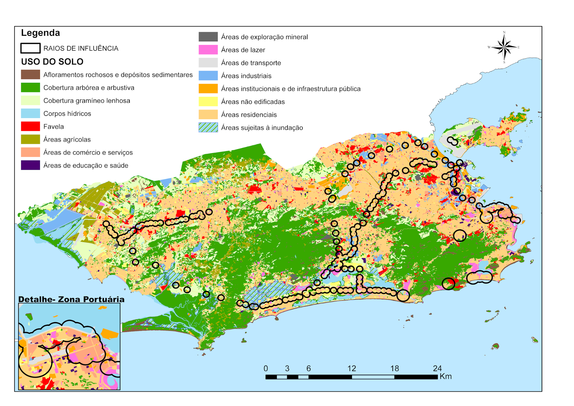
Figure 1: Land Use Map – 2009
Source: The authors, based on data from the Instituto Pereira Passos (2025)
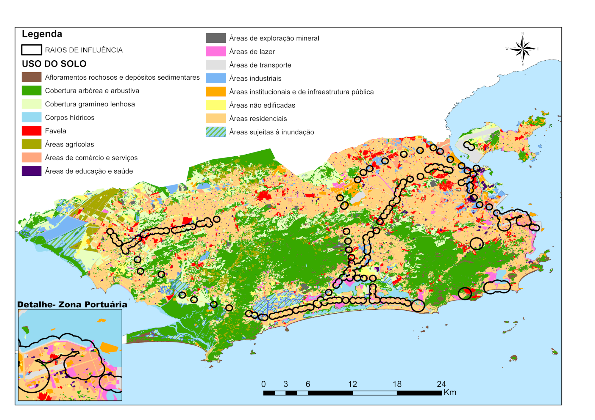
Figure 2: Land Use Map – 2019
Source: The authors, based on data from the Instituto Pereira Passos (2025)
Subsequently, the Intersect tool was applied to filter land use and occupation data from the two analyzed periods, restricting the analysis to areas located within the previously defined influence radii. The resulting data were then converted to raster format for submission in a suitable format to the Semi-Automatic Classification Plugin (SCP) of the QGIS 3.28 software.
Cross-classification of the data was performed using the SCP plugin and resulted in 144 relationships between land use and occupation classes across the two periods.
- Results obtained
4.1 Analysis of transformations
Cross-tabulation compares two classified images from different periods, identifying pixels that remained in the same class (no change) and pixels that transitioned between classes (with change) (Pontius et al., 2004).
The classification resulted in a transition matrix relating the 12 classes of 2009 to the 12 classes of 2019, yielding 144 possible combinations. Each cell represents the area (m²) that transitioned from one class in 2009 to another in 2019.
The matrix was reclassified into the following categories:
- No change: pixels that remained in the same class in both periods;
- With change: pixels that transitioned between classes, subdivided into:
- Urbanized: Non-urbanized → Urbanized;
- De-urbanized: Urbanized → Non-urbanized;
The illustrative excerpt shown in Figure 3 depicts the classification of areas that did or did not experience changes in land use and occupation between 2009 and 2019. Areas highlighted in green represent modifications, while areas highlighted in red indicate unchanged regions.
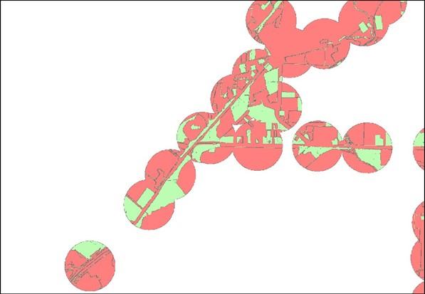
Figure 3: Excerpt of the classification of changes. In green, areas that underwent land-use modification; in red, areas where land use was preserved
Source: The authors, based on data from the Instituto Pereira Passos (2025)
From the classification output, areas that underwent transitions between groups, namely, from urbanized to non-urbanized or vice versa, were identified. Based on a new dataset, it was then possible to assess urban areas that transitioned from non-built-up or residential use to other forms of urban occupation. Area quantification in square meters and the calculation of percentages corresponding to each transformation category were performed using the QGIS 3.28 geoprocessing software.
4.2 Public transport overview
The analysis of transport demand for the 2009–2019 period provides context for the observed territorial transformations. Bus transport accounts for approximately 75% of total passengers, while the metro represents 14% and trains 11%, reinforcing the structural importance of the bus system in Rio de Janeiro’s mobility.
An accumulated increase in demand was observed up to 2015–2016: approximately 50% for buses, 53% for the metro, and 37% for trains. Subsequently, a decline of 27% in bus demand (2015–2019), 0.79% in metro demand (2016–2019), and 9% in train demand (2016–2019) was recorded. This inflection coincides with the post-mega-event period and the onset of the state-level economic crisis, highlighting the relationship between economic activity and the use of the transport system. Figure 4 presents the total number of passengers transported by land-based transport modes in the city.
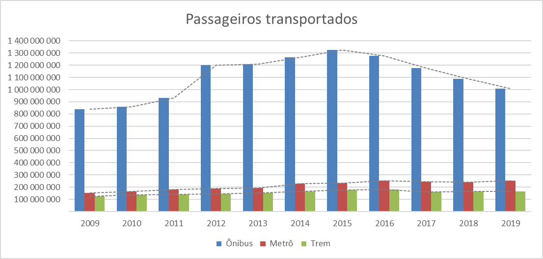
Figure 4: Chart showing the total number of passengers transported by land-based transport in the city of Rio de Janeiro
Source: The authors, based on data from the Instituto Pereira Passos (2025)
The chart highlights the predominance of bus transport, which accounts for approximately 75% of the total passengers transported between 2009 and 2019. The metro accounts for 14% of demand, and trains for approximately 11%. This pattern reinforces the structural importance of the bus system in Rio de Janeiro’s urban mobility, even with the implementation of new mass transport modes.
The analysis also shows an increase in demand across all three modes during the period, with cumulative growth of approximately 50% for buses up to 2015, 53% for the metro, and 37% for trains up to 2016. From 2015 to 2019, bus transport experienced a 27% decline in demand, while from 2016 to 2019, metro demand declined by 0.79% and train demand by approximately 9%. This inflection beginning in 2015–2016 coincides with the post-mega-event period and the onset of the economic crisis that affected the state of Rio de Janeiro, suggesting a relationship between economic activity, urban travel, and the use of the transport system.
4.3 Demand for new transport modes
Based on transaction data, that is, payments made through electronic ticketing at stations along the BRT, VLT, and metro corridors, an analysis of passenger demand was carried out for the period under consideration, as new dedicated and exclusive corridors were inaugurated. Figures 5, 6, and 7 illustrate the evolution of demand in the three main BRT corridors.
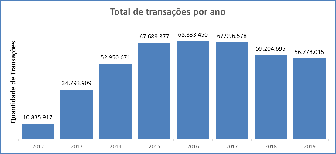
Figure 5: Chart showing the total number of transactions carried out in the Transoeste corridor.
Source: The authors, based on data from the Municipal Secretariat of Transport of Rio de Janeiro (2025)
The Transoeste corridor, the first to be implemented (2012), shows growth until 2015, followed by stabilization and decline after 2016, reflecting both the maturation of the system and the impacts of the regional economic crisis.
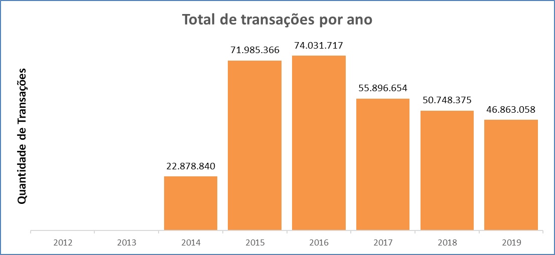
Figure 6: Chart showing the total number of transactions carried out in the Transcarioca corridor.
Source: The authors, based on data from the Municipal Secretariat of Transport of Rio de Janeiro (2025)
The Transcarioca corridor, inaugurated in 2014, connects Barra da Tijuca to Tom Jobim International Airport, serving an important demand for connections between areas of urban expansion and the city’s main airport facility. Demand peaked in 2016, followed by a subsequent decline.
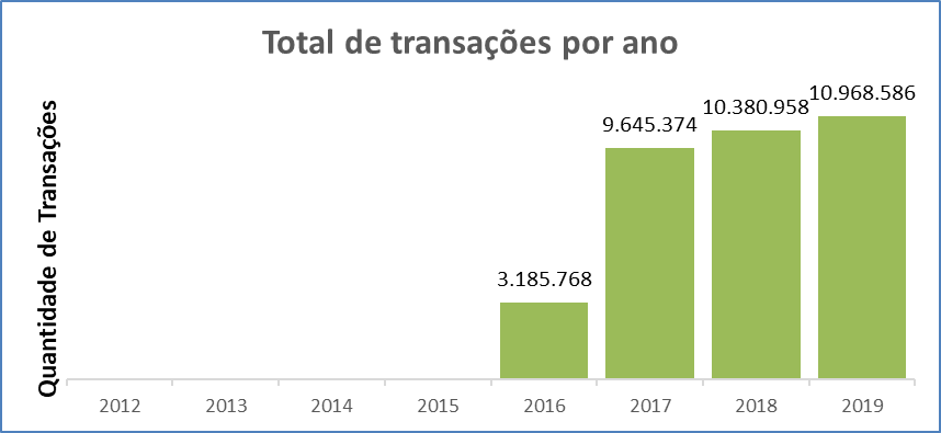
Figure 7: Chart showing the total number of transactions carried out in the Transolímpica corridor
Source: The authors, based on data from the Municipal Secretariat of Transport of Rio de Janeiro (2025)
The Transolímpica corridor, the most recent of the three and inaugurated in 2016, presents lower demand volumes than the other corridors. This may be related to the occupation profile of the areas served and to the shorter period of operation considered in the analysis. The decline observed across all three corridors from 2015–2016 coincides with the post-mega-event period and the onset of the state-level economic crisis.
While the BRT corridors play a structuring role in medium- and long-distance axes, the VLT (light rail vehicle) concentrates its operation on short-distance trips, mainly articulating with other modes in the city center.
The VLT, inaugurated in 2016 in central Rio de Janeiro, exhibits a demand pattern that reflects its function in intra-central mobility, with significant volumes that are nevertheless lower than those of medium- and high-capacity systems. The system plays an important role in the redevelopment of the port and central areas of the city.
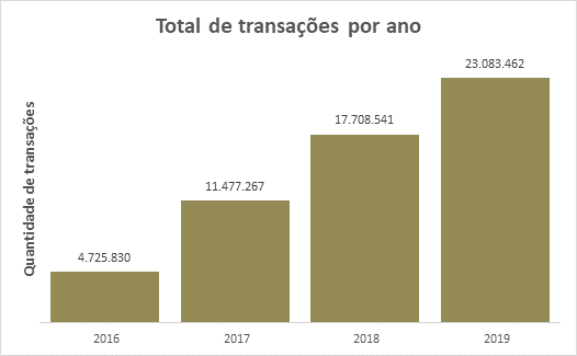
Figure 8: Chart showing the total number of transactions carried out on the VLT system.
Source: The authors, based on data from the Municipal Secretariat of Transport of Rio de Janeiro (2025)
Complementary to surface transport systems, high-capacity modes such as the metro strengthen network integration and expand connectivity between the central and peripheral areas of the city. The stations comprising metro line 4 recorded expressive demand volumes, demonstrating the attractiveness of this mode and its structuring role in linking the Barra da Tijuca axis to other areas of the city.
Figure 9: Chart showing the total number of transactions carried out at the new metro stations.
Source: The authors, based on data from the Municipal Secretariat of Transport of Rio de Janeiro (2025)
4.4 Land-use transformations in areas of influence
The results of the analysis comparing land-use and land-cover classifications from 2009 and 2019 within the areas of influence of the selected public transport stations made it possible to quantify the areas that did or did not undergo change during the observed period. The percentage distribution is presented in Table 1.
Table 1: Land-use changes
Type | Area (m²) | % |
With land-use change | 15 930 000 | 19.76 |
Without land-use change | 64 690 000 | 80.24 |
Source: The authors (2025)
The data reveal that approximately one fifth (19.76%) of the total area of influence of the new mass transit stations experienced land-use changes over the ten-year period analyzed. Although this percentage may appear modest at first glance, it represents a significant territorial transformation when considering the scale of intervention (approximately 16 km² of modified area) and the relatively short time span. It is important to emphasize that, according to the specialized literature, land-use changes in consolidated urban areas tend to occur gradually, and percentages above 15% within a decade indicate substantial transformations (Nigriello; Oliveira, 2013).
4.5 Analysis by station and passenger demand
Table 2 illustrates the analysis of the areas surrounding the stations with the highest cumulative demand between 2009 and 2019, located along one of the corridors that received structural interventions in the public transport system. The investigation of these areas seeks to identify evidence of a correlation between the intensity of station use and transformations in land use and occupation within their zones of influence. This approach is grounded in the theoretical assumption that the implementation and expansion of transport infrastructure act as drivers of territorial reorganization, promoting changes in urban dynamics and in the spatial distribution of economic activities (Cervero; Landis, 1997; Bertolini; Spit, 1998; Campos; Melo, 2005).
Table 2: BRT corridor, stations with the highest passenger demand
Station | Passengers transported during the period | Area that experienced change (m²) |
Terminal Alvorada | 72 551 948 | 26 017.56 |
Madureira (Paulo da Portela terminal) | 40 431 086 | 44 243.19 |
Jardim Oceânico terminal | 33 191 874 | 239 773.36 |
Mato Alto | 36 145 029 | 103 720.01 |
Santa Cruz terminal | 29 821 486 | 43 671.41 |
Source: The authors (2025).
The analysis of the BRT corridor reveals the following pattern: the Jardim Oceânico terminal, despite not having the highest passenger demand, records the largest area of territorial transformation. This phenomenon may be related to the socioeconomic profile of the region (Barra da Tijuca), where there is greater availability of land for real estate development and stronger pressure for verticalization. In contrast, the Alvorada terminal, which has the highest passenger demand in the system, shows a relatively smaller area of transformation, justified by the pre-existing urban consolidation of the region.
Table 3 illustrates the analysis of the areas surrounding the VLT stations with the highest cumulative demand between 2009 and 2019.
Table 3: VLT Corridor, stations with the highest passenger demand
Station | Passengers transported during the period | Area that underwent change (m²) |
Cinelândia | 5 106 735 | 54 637.93 |
Colombo | 4 825 114 | 249 810.80 |
Central | 4 257 392 | 317 685.61 |
Carioca | 4 187 177 | 249 810.80 |
Sete de Setembro | 3 995 519 | 225 058.91 |
Source: the authors (2025)
In the case of the VLT, it is observed that the Central station presents the largest area of transformation, which is directly related to the revitalization project of Rio de Janeiro’s port area (Porto Maravilha), which substantially modified land use in the region. The Colombo, Carioca, and Sete de Setembro stations also show significant transformations, all of them located in the central area, which underwent an intense process of urban redevelopment during the analyzed period.
Table 4 illustrates the analysis of the areas surrounding the Line 4 metro stations with the highest cumulative demand between 2009 and 2019.
Table 4: Metro corridor, Line 4 stations with the highest passenger demand
Station | Passengers transported during the period | Area that underwent change (m²) |
Jardim Oceânico | 42 911 877 | 239 773.36 |
Antero de Quental | 16 543 631 | 99 498.80 |
Nossa Senhora da Paz | 14 839 407 | 63 193.67 |
Jardim de Alah | 12 172 642 | 95 792.28 |
São Conrado | 11 587 692 | 167 878.28 |
Source: the authors (2025)
In the analysis of the Line 4 metro corridor, the Jardim Oceânico station stands out, as it integrates the system with the TransOeste BRT and presents both the highest passenger demand and one of the largest areas of transformation. The stations located in the South Zone (Antero de Quental, Nossa Senhora da Paz, and Jardim de Alah) showed moderate transformation areas, reflecting restrictions on verticalization in consolidated residential areas. The São Conrado station, in turn, records significant territorial transformation, which is associated with new real estate developments and improved accessibility in its surroundings.
4.6 Land Use Change Categories
The areas of influence of the stations were quantified and categorized according to land use change and permanence. Table 5 presents the classification results for the analyzed period.
Table 5: Changes in land use category
Category | Area (m²) | % |
Remained urbanized | 5 933 000 | 37 |
Became urbanized | 5 715 000 | 36 |
Became de-urbanized | 3 660 000 | 23 |
Remained non-urbanized | 624 300 | 4 |
Source: The authors (2025)
The results shown in Table 5 highlight the territorial processes triggered by the new transport infrastructures. Of the total area that underwent change (15.93 km²), 37% became effectively urbanized, demonstrating the inductive role of public transport in shaping land occupation. This process confirms classical urban planning theory regarding the structuring capacity of transport systems.
On the other hand, the percentage of areas that underwent de-urbanization (23%) stands out. This phenomenon may be related to several factors, including: (i) the removal of communities for the implementation of transport works; (ii) the creation of environmental protection areas; (iii) demolitions for future developments; or (iv) classification errors in the original data, an aspect that deserves deeper investigation in future studies.
Nevertheless, this factor requires careful examination due to the possibility of misinterpretation in photointerpretation processes. For example, the existence of halted construction works, popularly known as “urban skeletons,” may lead to inaccurate interpretations, classifying them as exposed soil or non-built-up areas.
The 37% of areas that remained urbanized but changed function indicates an intensification of land use in the vicinity of stations, with a likely replacement of low-density residential uses by commercial activities, services, or higher-density mixed uses. This pattern is consistent with the process of centrality formation identified by Paiva Neto (2018) when analyzing the public transport network as a structuring element of centralities in the city of Rio de Janeiro.
4.7 Specific land-use transformations
Finally, among the areas that remained classified as urbanized, those that exhibited functional change were identified, involving shifts from predominantly residential or non-built-up uses to categories associated with economic activities or urban infrastructure, such as commercial, industrial, institutional, transport, education, health, or mineral extraction uses. The distribution of these transformations is presented in Table 6.
Table 6: Changes from residential or non-urbanized areas to other functions
Land-use change | Area (m²) | % |
Residential to non-built-up | 866,2 | 14.60 |
Non-built-up to residential | 235,4 | 3.97 |
Residential to commerce and services | 166,1 | 2.80 |
Non-built-up to leisure | 140,1 | 2.36 |
Non-built-up to institutional | 122,9 | 2.07 |
Residential to institutional | 97,14 | 1.64 |
Informal settlement to residential | 91,3 | 1.54 |
Residential to industrial | 84,48 | 1.42 |
Non-built-up to industrial | 77,09 | 1.30 |
Non-built-up to informal settlement | 75,89 | 1.28 |
Non-built-up to transport | 72,92 | 1.23 |
Residential to leisure | 68,45 | 1.15 |
Non-built-up to commerce and services | 65,03 | 1.10 |
Residential to informal settlement | 56,32 | 0.95 |
Non-built-up to mineral extraction | 56,06 | 0.94 |
Informal settlement to non-built-up | 50,89 | 0.86 |
Residential to education and health | 50,92 | 0.86 |
Residential to transport | 41,54 | 0.70 |
Informal settlement to industrial | 41,21 | 0.69 |
Informal settlement to transport | 38,93 | 0.66 |
Non-built-up to education and health | 38,31 | 0.65 |
Informal settlement to institutional | 38,05 | 0.64 |
Informal settlement to mineral extraction | 33,1 | 0.56 |
Informal settlement to leisure | 30,68 | 0.52 |
Informal settlement to education and health | 30 | 0.51 |
Informal settlement to commerce and services | 24,05 | 0.41 |
Source: the authors (2025)
Table 6 provides a detailed overview of specific land-use transformations, revealing several noteworthy patterns:
a. Transitions from informal settlements: Approximately 5.4% of the total changed area corresponds to transformations originating from areas classified as informal settlements. The main destination uses were formal residential (1.54%), institutional (0.64%), and transport (0.66%), suggesting processes of land tenure regularization, implementation of public facilities, and possibly removals associated with mobility works and megaevents.
b. Urbanization of non-built-up areas: Transitions from non-built-up areas account for 9.9% of total changes. Conversions to residential (3.97%), leisure (2.36%), and institutional (2.07%) uses stand out, indicating a process of urban expansion within the areas of influence of the new stations. The significant conversion to residential use demonstrates the attractiveness generated by proximity to mass transit.
c. Transformations of residential areas: The most expressive result is the conversion of residential areas to non-built-up land (14.60%), corresponding to 866,200 m². Although this phenomenon appears paradoxical in light of theoretical expectations of densification near transport stations, it should not be immediately interpreted as contradicting the expected densification effects of transport systems (Cervero; Landis, 1997).
The literature indicates that land-use transformations associated with public transport investments often present a time lag between infrastructure implementation and the consolidation of densification and functional diversification processes (Bertolini; Spit, 1998). In the context of the interventions analyzed, this percentage may be associated with: (i) demolition of existing buildings for the implementation of larger and denser developments; (ii) expropriations carried out for mobility infrastructure and adjacent operational areas, including exclusive corridors, stations, and support facilities; (iii) removals of informal settlements for the construction of transport corridors, as documented by Faulhaber and Azevedo (2015), who identified more than 22,000 families removed in the context of urban interventions related to megaevents in Rio de Janeiro; and (iv) a period of severe state-level economic crisis (2016–2019), which significantly affected the real estate market and construction activity in the municipality (Rolnik; Klintowitz, 2011).
Therefore, although this percentage of de-urbanization deserves attention and deeper investigation in future studies, its interpretation as definitive counterevidence to transport-induced urbanization processes should be relativized. The conversion to commerce and services (2.80%), although quantitatively less expressive, indicates a process of functional diversification characteristic of the formation of urban centralities, as identified by Paiva Neto (2018) when analyzing the public transport network as a structuring element of centralities in Rio de Janeiro.
It should also be noted that the cross-classification was performed automatically using a GIS tool, based on data provided by the Instituto Pereira Passos. Thus, there is the possibility of classification errors, particularly in transitions from Residential to Non-built-up categories, which require visual validation in critical areas such as Recreio, Vargens, or the Port Zone to confirm whether they represent actual demolitions or differences in photointerpretation.
d. Functional diversification: A significant diversification of uses is observed, with conversions to education and health (2.02%), institutional (3.71%), and leisure (3.68%), suggesting that areas near stations attracted not only economic activities but also public facilities and spaces for social interaction, fundamental elements for complete and sustainable neighborhoods.
- Discussion of results
The results obtained confirm the correlation between the expansion of public transport infrastructure and transformations in urban land use and occupation, corroborating the theoretical framework presented. The magnitude of the observed changes (approximately 20% of the area of influence) over a relatively short period (10 years) highlights the structuring role that mass transit systems play in territorial dynamics. In addition, the analysis of passenger demand by station should be considered in conjunction with other criteria, such as the socioeconomic profile of the area, land availability, and urban regulation, in order to understand regional transformation processes.
5.1 Implications for integrated planning
The findings reinforce the need for public policies that effectively integrate urban mobility planning and land-use regulation, as advocated by the National Urban Mobility Policy and municipal planning instruments. The identification of a 37% rate of land-use change demonstrates that public transport interventions create opportunities to guide urban growth in a more sustainable manner.
However, as warned by Lima Neto and Galindo (2015), the mere existence of legal instruments such as Urban Mobility Plans does not guarantee their effectiveness. It is essential that these plans be accompanied by mechanisms for capturing land value increases to finance urban improvements, land-use control instruments to prevent gentrification and socio-spatial exclusion, effective social participation in planning processes, and articulation with housing and economic development policies.
5.2 Polycentricity and travel patterns
The diversification of land uses observed in the areas of influence of the new stations, marked by an increase in commercial activities (2.80% of conversions from residential areas), services, and institutional facilities (3.71%), corroborates the process of polycentricity identified by Mello (2019) in the Rio de Janeiro Metropolitan Region (RMRJ). Using origin–destination data, Mello (2019) demonstrates that the RMRJ is experiencing a decentralization of activities, with the consolidation of centralities based on trip attraction. Although the monocentric structure remains relevant, new destinations have generated differentiated demands and tangential travel patterns.
Paiva Neto (2018) identifies that diversified economic functions have emerged around major stations, forming local and regional centralities. Accessibility provided by transport infrastructure is a determining factor in the location of developments, fostering a concentration of activities within station influence areas.
The process of polycentricity is gradual and requires a time horizon longer than the ten years analyzed. Bertolini and Spit (1998) identified that territorial transformations may take between 15 and 25 years to fully consolidate. In this study, two key periods must be considered: the completion of the first major urban mobility interventions in 2016 and the subsequent period coinciding with a severe state-level economic crisis, which dampened territorial transformations.
For polycentricity to fully materialize, new centralities must offer not only land-use diversity but also qualified employment, specialized services, and urban amenities capable of effectively reducing dependence on long-distance commuting. The data presented in Tables 2, 3, and 4 suggest that this process is underway but remains incipient. Stations such as Jardim Oceânico and those along the VLT corridor in the central area show potential for consolidation as effective centralities; however, this will depend on active local economic development policies and appropriate land-use regulation.
5.3 Metropolitan governance challenges
The challenges of planning and financing urban mobility identified by Luft (2020) become evident when analyzing the mismatch between observed territorial transformations and the absence of integrated policies to guide them. The lack of coordination among different governmental levels and the discontinuity between plans developed in different periods result in uncontrolled territorial transformations, which may exacerbate inequalities rather than mitigate them.
From the perspective of the 2011 Master Plan (LC 111/2011), this study does not encompass the new Sustainable Urban Development Master Plan of the Municipality of Rio de Janeiro (Complementary Law No. 270/2024). The new municipal regulatory framework incorporates specific guidelines for integrating urban mobility and land-use planning.
The interventions analyzed were largely driven by mega-events, characterized by accelerated schedules and short-term objectives, which compromised long-term integrated planning. The disarticulation between the PDTU-2015 and the PEDUI-2018, identified by Luft (2020), exemplifies how insufficient intergovernmental coordination mechanisms resulted in fragmented and sometimes contradictory policies. The creation of the Rio Metrópole Institute (IRM) and the institutionalization of the PEDUI as a State Law represent advances in the metropolitan governance framework, establishing coordination structures between municipal and metropolitan planning instruments.
At the municipal level, the approval of Complementary Law No. 270/2024, which revises the Sustainable Urban Development Master Plan of Rio de Janeiro, establishes guidelines for alignment with the PEDUI and incorporates urban instruments aimed at integrating mobility and land use in areas surrounding mass transit stations. Although these recent regulatory advances were not in force during the period analyzed (2009–2019), they constitute fundamental elements for guiding future public transport interventions and mitigating the fragmented territorial transformation processes identified in this study.
5.4 Equity and spatial justice
Transformations involving informal settlement areas require special attention from the perspective of urban equity and spatial justice. The data indicate that 5.4% of transformations originated in areas classified as informal settlements, with diverse outcomes. While some processes may represent genuine improvements, such as land regularization (conversion to formal residential use, 1.54%) and access to public facilities (conversion to institutional use, 0.64%), it is essential to investigate the extent to which population removals and displacements associated with mobility works respected the constitutional right to housing and to the city.
Studies on urban interventions linked to mega-events in Rio de Janeiro document that thousands of families were removed, often relocated to peripheral areas with reduced access to transport, employment, and services (Faulhaber; Azevedo, 2015). The conversion of 0.66% of informal settlement areas to transport use (38,930 m²) suggests that part of the observed transformations resulted directly from removals for infrastructure implementation.
Property value appreciation induced by proximity to mass transit may also generate indirect gentrification processes, even without forced removals. Rising real estate prices and living costs can displace low-income populations to peripheral areas with lower accessibility, reproducing socio-spatial inequalities. This phenomenon is particularly concerning given that 14.60% of transformations correspond to the conversion of residential areas to non-built land, which may indicate speculative processes that exacerbate the housing crisis.
Land-use policies should therefore incorporate robust social protection mechanisms, such as: (i) mandatory allocation of a significant share of social housing in developments near transport stations; (ii) price controls or housing subsidies within station influence areas; (iii) land regularization programs that ensure the permanence of the original population; and (iv) effective participation of affected communities in decision-making processes related to urban projects.
6 Final considerations
This study investigated transformations in land use and occupation in Rio de Janeiro resulting from changes in the public transport system between 2009 and 2019, with a focus on the areas of influence of new metro, BRT, and LRT stations. The results confirm a correlation between the expansion of transport infrastructure and changes in territorial dynamics.
Based on the data obtained, a significant amount of land-use change was identified in the areas of influence of the new stations, affecting approximately 20% of the total influence area. Of these areas, 36% underwent urbanization and 37% remained urbanized but changed function, evidencing functional diversification characteristic of local centralities. These patterns are consistent with the process of polycentricity identified by Mello (2019), in which new destinations consolidate through accessibility provided by transport infrastructure.
The observed diversification, marked by conversions to commercial and service uses (2.80%), institutional uses (1.64%), and education and health facilities (0.86%), indicates that areas of influence attract economic activities and urban facilities, consolidating themselves as sub-centralities.
The percentage of de-urbanization (23%) and the conversion of residential areas to non-built land (14.60%) require contextualized interpretation. A significant portion of these changes is associated with transitional processes of urban renewal, expropriations, removals, and speculative practices within a context of economic crisis. The literature demonstrates that densification processes present a time lag of 15 to 25 years (Bertolini; Spit, 1998).
Considering that the interventions were completed in 2016 and the subsequent period was marked by a state-level economic crisis, the data capture an initial phase of an ongoing transformation process.
The challenges identified in the specialized literature regarding the effectiveness of Urban Mobility Plans as public policy instruments, metropolitan governance difficulties, and the lack of articulation among different planning levels are empirically manifested in the observed transformations. Without integrated policies to guide territorial changes induced by transport infrastructure, the risk of exacerbating socio-spatial inequalities and undermining urban sustainability increases.
For the continuation of this research, the following directions are suggested to deepen the analysis:
- Temporal expansion of the analysis: Investigate periods beyond the scope of this study (up to 2030 and 2035) to verify whether non-built areas are converted into higher-density uses and to confirm or refute the hypothesis of a transitional phase. Combine quantitative analysis with field studies to better understand specific processes.
- Consolidation of centralities: Assess whether areas with functional diversification have consolidated as centralities capable of attracting trips.
- Incorporation of socioeconomic variables: Analyze differentiated impacts on population groups, including income, race, gender, and social vulnerability.
- Analysis of other transport modes: Include conventional buses, complementary transport, and active mobility to achieve a more comprehensive understanding of the transport–territory relationship.
- Real estate valorization studies: Investigate how land-use changes relate to land and property value appreciation.
- Assessment of gentrification processes: Examine population displacement and changes in the socioeconomic profile of residents in transformed areas.
- Predictive modeling: Develop models capable of forecasting future territorial transformations based on planned transport interventions, supporting integrated planning.
- Comparative analysis: Compare the patterns observed in Rio de Janeiro with those of other Brazilian and international metropolitan areas to identify specificities and general trends.
Therefore, to build a more accurately calibrated integrated planning model, it is necessary to study additional parameters and their influence on urban land occupation. Emphasis is placed on continued research efforts and methodological improvements aimed at developing effective instruments for sustainable and equitable urban planning in Brazilian metropolises.
References
VASCONCELOS, P. de A. ABREU, Maurício de. A evolução urbana do Rio de Janeiro. Rio de Janeiro: IPLANRIO; Zahar, 1987. 147 p. RUA: Revista de Urbanismo e Arquitetura , [S. l.], v. 1, n. 1, 2008. DOI: 10.9771/rua.v1i0.3073.
BARBALHO, Leonardo Vieira. Os desafios na implantação de um Cadastro Territorial Multifinalitário no município do Rio de Janeiro. Dissertação (Mestrado em Engenharia Urbana) – Programa de Engenharia Urbana, Universidade Federal do Rio de Janeiro, Rio de Janeiro, 2020.
BARBALHO, Leonardo Vieira; LIMA, Fernando Rodrigues; COELHO FILHO, Luiz Carlos Teixeira. Challenges of implementing a land cadastre in Rio de Janeiro: the Bangu case study. Municipal Engineer, v. 176, n. 4, p. 245-256, jul. 2023. DOI: 10.1680/jmuen.22.00040.
BERTOLINI, L.; SPIT, T. Cities on Rails: the Redevelopment of Railway Stations and their Surroundings . Routledge, London. 1998. DOI: 10.4324/9780203980439.
BRASIL. Lei nº 12.587, de 3 de janeiro de 2012. Brasília, DF: [s.n.], 3 jan. 2012. Institui as diretrizes da Política Nacional de Mobilidade Urbana.
CAMPOS, Vânia Barcellos Gouvêa; MELO, Bruna Pinheiro de. Estratégias integradas de transporte e uso do solo visando a redução de viagens por automóvel. In: CONGRESSO DE PESQUISA E ENSINO EM TRANSPORTES, 15., 2005, Goiânia. Anais [...]. Goiânia: ANPET, 2005.
CARVALHO, Carlos Henrique Ribeiro de. Desafios da mobilidade urbana no Brasil. Texto para Discussão. n. 2198. Brasília: IPEA, 2016.
CAVALCANTI, Sávio Alves et al. Estimativa das penalidades associadas com os transbordos em sistemas integrados de transporte público. In: CONGRESSO DE PESQUISA E ENSINO EM TRANSPORTES, 26., Joinville. Anais [...]. Joinville: ANPET, 2012.
CERVERO, Robert; KOCKELMAN, Kara. Travel demand and the 3Ds: Density, diversity, and design. Transportation Research Part D: Transport and Environment, v. 2, n. 3, p. 199-219, 1997. DOI: 10.1016/S1361-9209(97)00009-6.
CERVERO, Robert; LANDIS, John. Twenty years of the Bay Area Rapid Transit system: Land use and development impacts. Transportation Research Part A: Policy and Practice, v. 31, n. 4, p. 309-333, 1997. DOI: 10.1016/S0965-8564(96)00027-4.
COSTELHA, Laís de Andrade; BARBALHO, Leonardo Vieira; MARTINS ALVES, Rosane. Acessibilidade ao transporte público e uso do solo utilizando ferramentas de geoprocessamento: bairro do Rio Comprido (RJ). Boletim do Gerenciamento, [S.l.], v. 38, n. 38, out. 2023. ISSN 2595-6531. DOI: 10.46675/bgppe.v38i38.1039.
DITTMAR, Hank; OHLAND, Gloria (Org.). The New Transit Town: Best Practices in Transit-Oriented Development. Washington, DC: Island Press, 2004. ISBN 978-1559639187.
FAULHABER, Lucas; AZEVEDO, Lena. SMH 2016: Remoções no Rio de Janeiro Olímpico. Rio de Janeiro: Mórula Editorial, 2015. ISBN 978-85-65679-47-7.
LIMA NETO, Vicente Correia; GALINDO, Ernesto Pereira. Planos de mobilidade urbana: instrumento efetivo da política pública de mobilidade?. Paranoá, [S. l.], v. 6, n. 9, 2013. DOI: 10.18830/issn.1679-0944.n9.2013.12291.
LUFT, Rosangela Maria. Planejamento e financiamento da mobilidade urbana na Região Metropolitana do Rio de Janeiro. Tese (Doutorado em Planejamento Urbano e Regional), Instituto de Pesquisa e Planejamento Urbano e Regional, Universidade Federal do Rio de Janeiro, Rio de Janeiro, 2020.
MELLO, Bernardo Patta de Albuquerque. Policentralidade e mobilidade na Região Metropolitana do Rio de Janeiro. Dissertação (Mestrado em Engenharia de Transportes), Programa de Engenharia de Transportes, COPPE, Universidade Federal do Rio de Janeiro, Rio de Janeiro, 2019.
MELO, Francisco de Assis da Silva. Transporte público, acessibilidade urbana e desigualdades socioespaciais na Região Metropolitana de Belo Horizonte. Dissertação (Mestrado em Geografia), Instituto de Geociências, Universidade Federal de Minas Gerais, Belo Horizonte, 2013.
NIGRIELLO, Andreina; OLIVEIRA, Rafael Henrique. A rede de transporte e a ordenação do espaço urbano. Revista dos Transportes Públicos - ANTP, São Paulo, v. 35, n. 133, p. 101-116. 2013.
PAIVA NETO, José Brandão de. A rede de transporte público como estruturadora de centralidades: análise da cidade do Rio de Janeiro. Dissertação (Mestrado em Engenharia de Transportes), Programa de Engenharia de Transportes, COPPE, Universidade Federal do Rio de Janeiro, Rio de Janeiro, 2018. 164 p.
PONTIUS, R. Gil et al. Detecting important categorical land changes while accounting for persistence. Agriculture, Ecosystems & Environment, v. 101, n. 2-3, p. 251-268, 2004. DOI: 10.1016/j.agee.2003.09.008.
RIO DE JANEIRO (Estado). Lei Complementar nº 184, de 27 de dezembro de 2018. Dispõe sobre a Região Metropolitana do Rio de Janeiro, sua composição, organização e gestão, define as funções públicas e serviços de interesse comum, cria a autoridade executiva da Região Metropolitana do Rio de Janeiro e dá outras providências. Diário Oficial do Estado do Rio de Janeiro, Rio de Janeiro, 28 dez. 2018.
RIO DE JANEIRO (Estado). Lei nº 11.021, de 16 de janeiro de 2025. Institui o Plano Estratégico de Desenvolvimento Urbano Integrado da Região Metropolitana do Rio de Janeiro - PEDUI e dá outras providências. Diário Oficial do Estado do Rio de Janeiro, Rio de Janeiro, 17 jan. 2025.
RIO DE JANEIRO (Município). Decreto Rio nº 45.781, de 3 de abril de 2019. Institui o Plano de Mobilidade Urbana Sustentável do Município do Rio de Janeiro - PMUS-Rio. Diário Oficial do Município do Rio de Janeiro, Rio de Janeiro, 4 abr. 2019.
RIO DE JANEIRO (Município). Lei Complementar nº 270, de 16 de janeiro de 2024. Dispõe sobre a Política Urbana e Ambiental do Município, institui a revisão do Plano Diretor de Desenvolvimento Urbano Sustentável do Município do Rio de Janeiro e dá outras providências. Diário Oficial do Município do Rio de Janeiro, Rio de Janeiro, 17 jan. 2024
ROLNIK, Raquel; KLINTOWITZ, Danielle. Mobilidade na cidade de São Paulo. Estudos Avançados, São Paulo, v. 25, n. 71, p. 89-108, 2011. DOI: 10.1590/S0103-40142011000100007.
SILVA, Robson Dias da. Possibilidades e limites do planejamento e da gestão metropolitana: a experiência da Região Metropolitana do Rio de Janeiro. Tese (Doutorado em Planejamento Urbano e Regional), Instituto de Pesquisa e Planejamento Urbano e Regional, Universidade Federal do Rio de Janeiro, Rio de Janeiro, 2013.
VASCONCELLOS, Eduardo Alcântara de. Políticas de transporte no Brasil: a construção da mobilidade excludente. Barueri: Manole, 2013. ISBN 978-85-204-3539-2.
About the Authors
Luiz Henrique de Carvalho Freires is a Cartographic Engineer (State University of Rio de Janeiro), with experience in the collection, processing, and analysis of geographic data, as well as skills in spatial modeling and the development of solutions for urban, environmental, and urban mobility planning. He is a master’s student in Urban Engineering at the Federal University of Rio de Janeiro, with research focused on identifying areas vulnerable to environmental disasters through geoprocessing techniques.
Leonardo Vieira Barbalho is a PhD candidate in Geomatics Engineering at the Universitat Politècnica de València and holds a master’s degree in Urban Engineering from the Federal University of Rio de Janeiro (UFRJ). He earned his undergraduate degree in Cartographic Engineering from the State University of Rio de Janeiro (UERJ) and has technical training in Surveying from SENAI-MG. He also holds specializations in Geoprocessing, Remote Sensing, and Topography. He is an Assistant Professor at the Polytechnic School of the Federal University of Rio de Janeiro (POLI/UFRJ). He has professional experience in digital cartography, geoprocessing, and topography, and is a researcher in the areas of territorial planning and management and multipurpose cadastre.
Fernando Rodrigues Lima holds a PhD in Production Engineering from the Federal University of Rio de Janeiro (PEP/COPPE/UFRJ, 1993), a master’s degree in Production Engineering from the same institution (PEP/COPPE/UFRJ, 1987), a specialization in Advanced Studies in Policy and Strategy (CAEPE) from the Brazilian War College (ESG, 1997), and a bachelor’s degree in Architecture and Urbanism from the Federal University of Rio de Janeiro (FAU/UFRJ, 1985). He is a Full Professor at the Polytechnic School of the Federal University of Rio de Janeiro (POLI/UFRJ) and a permanent faculty member of the Graduate Program in Urban Engineering (PEU). He coordinated two International Exchange Projects with the Université de Technologie de Compiègne (UTC): BRAFITEC/CAPES (2011–2018) and PVE/CSF/CNPq (2014–2016). Since 2021, he has been a member of the Working Group on Infrastructure, Environment, and Green Areas of the UFRJ Master Plan 2030, and since 2021, a member of a CNPq Research Group on Smart Campus in partnership with the University of Brasília (UnB).
Author Contributions
Conceptualization, [L.H.C.F.]; methodology, [L.V.B., L.H.C.F.]; software [L.H.C.F., L.V.B., F.R.L.]; validation, [L.V.B.]; formal analysis, [L.H.C.F.]; investigation, [L.H.C.F., L.V.B.]; writing—original draft preparation, [L.H.C.F.]; writing—review and editing [L.V.B., F.R.L.]; supervision, [L.V.B., F.R.L.]. All authors have read and agreed to the published version of the manuscript.
Conflicts of Interest
The authors declare no conflicts of interest.
About Coleção Estudos Cariocas
Coleção Estudos Cariocas (ISSN 1984-7203) is a publication dedicated to studies and research on the Municipality of Rio de Janeiro, affiliated with the Pereira Passos Institute (IPP) of the Rio de Janeiro City Hall.
Its objective is to disseminate technical and scientific production on topics related to the city of Rio de Janeiro, as well as its metropolitan connections and its role in regional, national, and international contexts. The collection is open to all researchers (whether municipal employees or not) and covers a wide range of fields — provided they partially or fully address the spatial scope of the city of Rio de Janeiro.
Articles must also align with the Institute’s objectives, which are:
- to promote and coordinate public intervention in the city’s urban space;
- to provide and integrate the activities of the city’s geographic, cartographic, monographic, and statistical information systems;
- to support the establishment of basic guidelines for the city’s socioeconomic development.
Special emphasis will be given to the articulation of the articles with the city's economic development proposal. Thus, it is expected that the multidisciplinary articles submitted to the journal will address the urban development needs of Rio de Janeiro.